| This article needs additional citations for verification. Please help improve this article by adding citations to reliable sources. Unsourced material may be challenged and removed. Find sources: "Weida" White Elster – news · newspapers · books · scholar · JSTOR (February 2024) (Learn how and when to remove this message) |
River in Thuringia, Germany
| Weida | |
|---|---|
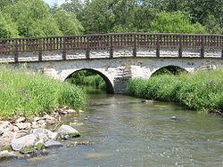
 The Weida in Lawitz The Weida in Lawitz | |
| Location | |
| Country | Germany |
| State | Thuringia |
| Physical characteristics | |
| Source | |
| • location | near Pausa |
| • elevation | 500 m (1,600 ft) |
| Mouth | |
| • location | White Elster |
| • coordinates | 50°47′44″N 12°5′21″E / 50.79556°N 12.08917°E / 50.79556; 12.08917 |
| Length | 57 km (35 mi) |
| Basin features | |
| Progression | White Elster→ Saale→ Elbe→ North Sea |
The Weida (German: [ˈvaɪdaː] ) is a non-navigable river in eastern Thuringia, Germany, left tributary of the White Elster. Most of its course is situated in the district of Greiz.
The Weida's source is near Pausa in Saxony; it then flows through the Thuringian Highland passing Zeulenroda-Triebes and through the eponymous Weida. It then feeds into the White Elster near Wünschendorf/Elster. Its tributaries include the Auma and the Leuba.
References
- Schwientek, Marc; Osenbrück, Karsten; Fleischer, Matthias (2013). "Investigating hydrological drivers of nitrate export dynamics in two agricultural catchments in Germany using high-frequency data series". Environmental Earth Sciences. 69 (2): 381–393. doi:10.1007/s12665-013-2322-2.
This Greiz district location article is a stub. You can help Misplaced Pages by expanding it. |
This article related to a river in Thuringia is a stub. You can help Misplaced Pages by expanding it. |