Township in Kansas, United States
| Welda Township | |
|---|---|
| Township | |
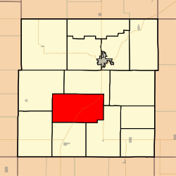
 Location in Anderson County Location in Anderson County | |
| Coordinates: 38°09′45″N 095°19′31″W / 38.16250°N 95.32528°W / 38.16250; -95.32528 | |
| Country | United States |
| State | Kansas |
| County | Anderson |
| Area | |
| • Total | 44.8 sq mi (116.0 km) |
| • Land | 44.4 sq mi (115.1 km) |
| • Water | 0.4 sq mi (1.0 km) 0.83% |
| Elevation | 1,079 ft (329 m) |
| Population | |
| • Total | 290 |
| • Density | 6/sq mi (2.5/km) |
| GNIS feature ID | 0477893 |
Welda Township is a township in Anderson County, Kansas, United States. As of the 2010 census, its population was 290.
Geography
Welda Township covers an area of 44.8 square miles (116.0 km) and contains no incorporated settlements and one census-designated place, Welda. According to the USGS, it contains two cemeteries: Wardell and Welda.
References
- "Geographic Identifiers: 2010 Demographic Profile Data (G001): Welda township, Anderson County, Kansas". U.S. Census Bureau, American Factfinder. Archived from the original on February 12, 2020. Retrieved May 13, 2013.
External links
- City-Data.com
- USD 365, local school district
| Municipalities and communities of Anderson County, Kansas, United States | ||
|---|---|---|
| County seat: Garnett | ||
| Cities |  | |
| CDPs | ||
| Unincorporated communities | ||
| Ghost towns | ||
| Townships | ||
This article about a location in Anderson County, Kansas is a stub. You can help Misplaced Pages by expanding it. |