| West Coolup Western Australia | |||||||||||||||
|---|---|---|---|---|---|---|---|---|---|---|---|---|---|---|---|
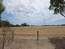
 Field in the rural suburb of West Coolup Field in the rural suburb of West Coolup | |||||||||||||||
| Coordinates | 32°46′S 115°47′E / 32.76°S 115.78°E / -32.76; 115.78 | ||||||||||||||
| Population | 182 (SAL 2021) | ||||||||||||||
| Postcode(s) | 6214 | ||||||||||||||
| Area | 84 km (32 sq mi) | ||||||||||||||
| Location | |||||||||||||||
| LGA(s) | Shire of Murray | ||||||||||||||
| State electorate(s) | Murray-Wellington | ||||||||||||||
| Federal division(s) | Canning | ||||||||||||||
| |||||||||||||||
West Coolup is a rural locality of the Shire of Murray in the Peel Region of Western Australia, located on the eastern shore of the Harvey Estuary.
The Shire of Murray and the locality of West Coolup are located on the traditional land of the Pindjarup people of the Noongar nation. The Pindjarup language is now considered extinct but the Noongar people remain present in the region.
West Coolup was settled relatively late compared to neighbouring localities, with a local school opening in 1899. In 1911, West Coolup Hall was opened as the focal point of the local community. The hall, now heritage-listed, has been the home of the Peel Districts Pistol Club.
References
- Australian Bureau of Statistics (28 June 2022). "West Coolup (suburb and locality)". Australian Census 2021 QuickStats. Retrieved 28 June 2022.

- "SLIP Map". maps.slip.wa.gov.au. Landgate. Retrieved 11 August 2023.
- "NationalMap". nationalmap.gov.au. Geoscience Australia. Retrieved 11 August 2023.
- "Pindjarup". www.boodjar.sis.uwa.edu.au. University of Western Australia. Retrieved 11 August 2023.
- "Pindjarup (WA)". www.samuseum.sa.gov.au. South Australian Museum. Retrieved 11 August 2023.
- "West Coolup Hall". inherit.stateheritage.wa.gov.au. Heritage Council of Western Australia. Retrieved 11 August 2023.
| Towns, suburbs and localities in the Shire of Murray, Peel Region, Western Australia | |
|---|---|
| Major settlements | |
| Other settlements | |