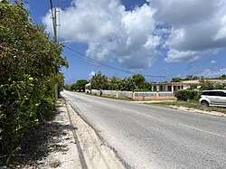
| West End | |
|---|---|
| District | |
 | |
 | |
| Coordinates: 18°10′18″N 63°09′00″W / 18.17162°N 63.15010°W / 18.17162; -63.15010 | |
| Country | |
| Overseas Territory | Anguilla |
| Area | |
| • Land | 8.07 km (3.12 sq mi) |
| Population | |
| • Total | 813 |
West End is one of the fourteen Districts of Anguilla. Its population at the 2011 census was 813.
Education
There is one government school in the town, Alwyn Allison Primary School. Albena Lake-Hodge Comprehensive School in The Valley serves secondary students.
Demographics
| Year | 1974 | 1984 | 1994 | 2001 | 2011 |
|---|---|---|---|---|---|
| Population | 479 | 402 | 611 | 736 | 813 |
References
- ^ "Anguilla census data". Statoids.com. Retrieved 11 May 2021.
- "Schools." Government of Anguilla. Retrieved on December 7, 2017.
| Anguilla | ||
|---|---|---|
| History | ||
| Districts | ||
| Education |
| |
| Transport | ||
| Landmarks | ||
| Symbols | ||
| This list is incomplete. | ||
18°10′18″N 63°09′00″W / 18.17162°N 63.15010°W / 18.17162; -63.15010
This Anguilla location article is a stub. You can help Misplaced Pages by expanding it. |
