| Wildhorse Creek | |
|---|---|
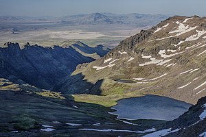
 Wildhorse Lake and Canyon Wildhorse Lake and Canyon | |
 | |
| Location | |
| Country | United States |
| State | Oregon |
| County | Harney |
| Physical characteristics | |
| Source | Steens Mountain |
| • location | Oregon |
| • coordinates | 42°38′16″N 118°35′07″W / 42.63778°N 118.58528°W / 42.63778; -118.58528 |
| • elevation | 8,943 ft (2,726 m) |
| Mouth | Alvord Lake |
| • coordinates | 42°24′26″N 118°36′24″W / 42.40722°N 118.60667°W / 42.40722; -118.60667 |
| • elevation | 4,026 ft (1,227 m) |
| National Wild and Scenic Rivers System | |
| Type | Wild |
| Designated | October 30, 2000 |
Wildhorse Creek is a tributary of Alvord Lake in Harney County in the U.S. state of Oregon. It originates at a spring on Steens Mountain and flows generally south through Wildhorse Canyon to the shallow alkaline lake, south of the Alvord Desert and north of the unincorporated community of Fields.
Near the headwaters, the creek enters and exits Wildhorse Lake, which lies in a hanging valley. The upper 7-mile (11 km) of the creek, including Wildhorse Lake, are part of the National Wild and Scenic Rivers System. In addition, a 2.6-mile (4.2 km) tributary, Little Wildhorse Creek, is part of the system. Wildhorse Creek and Little Wildhorse Creek flow through the Steens Mountain Wilderness before entering private land at lower elevations.
Designated "wild", the creek's watershed is home to mule deer, elk, bighorn sheep and pronghorn. Wildhorse Lake, covering about 20 acres (8 ha), supports populations of Lahontan cutthroat trout, which spawn in the creek.
The ghost town of Andrews, Oregon, lies in the Wildhorse Valley west of the creek. Slightly north of the ghost town is the Wildhorse Valley Airport.
Tributaries
From source to mouth, the named tributaries of Wildhorse Creek begin with Little Wildhorse Creek, which flows into the main stem in Wildhorse Canyon. In the Wildhorse Valley east of Steens Mountain, Willow, Willow Spring, Deppy, Stonehouse, Spring, Wilson, Andrews, Butte, Juniper, and Miranda creeks enter the main stem. All the tributaries enter from the right.
See also
References
- ^ "Wildhorse Creek". Geographic Names Information System (GNIS). United States Geological Survey (USGS). November 28, 1980. Retrieved December 10, 2015.
- Source elevation derived from Google Earth search using GNIS source coordinates.
- "Alvord Lake and Basin". Audubon Society of Portland. Retrieved December 12, 2015.
- ^ "United States Topographic Map". United States Geological Survey. Retrieved December 9, 2015 – via ACME Mapper.
- ^ "Wildhorse & Kiger Creeks, Oregon". National Wild and Scenic Rivers System. Retrieved December 10, 2015.
- Sheehan, Madelynne Diness (2005). Fishing in Oregon: The Complete Oregon Fishing Guide (10th ed.). Scappoose, Oregon: Flying Pencil Publications. p. 298. ISBN 0-916473-15-5.