Human settlement in England
| Wimbledon Park | |
|---|---|
 Wimbledon Park Lake Wimbledon Park Lake | |
 | |
| Population | 11,197 (2011 Census. Ward) |
| London borough | |
| Ceremonial county | Greater London |
| Region | |
| Country | England |
| Sovereign state | United Kingdom |
| Post town | LONDON |
| Postcode district | SW19 |
| Dialling code | 020 |
| Police | Metropolitan |
| Fire | London |
| Ambulance | London |
| London Assembly | |
| 51°26′19″N 0°12′19″W / 51.438734°N 0.205200°W / 51.438734; -0.205200 | |
Wimbledon Park is the name of an urban park in Wimbledon and also of the suburb south and east of the park and the Wimbledon Park tube station. The park itself is 27 hectares (67 acres) in area. The All England Lawn Tennis and Croquet Club is immediately to the west of the park. Wimbledon Park is not part of Wimbledon Common, which is situated further to the west up the hill.
Early history
The original park comprised part of the grounds of Wimbledon manor house, the seat of the manor of Wimbledon, situated on the hill to the south, near St Mary's Church, Wimbledon the old parish church of Wimbledon. A series of owners enlarged the park northwards and eastwards. By the 19th century it was at its largest extent, and one of the homes of the Earls Spencer, lords of the manor. The park had been landscaped in the 18th century by Capability Brown when the lake was formed by constructing a dam across a brook that flows from the springline near Wimbledon Common down to the River Wandle in Earlsfield.
In 1846, the 4th Earl Spencer sold the estate and house to John Augustus Beaumont a property developer who laid out new roads and sold plots of land for house building. Two roads still bear his name today – Augustus Road and Beaumont Road. Development of the area was slow at first, but continued throughout the second half of the 19th century, gradually nibbling away at the parkland.
20th century onwards
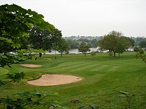
The modern park was purchased by the Borough of Wimbledon just before the First World War and is, with its ornamental lake, the grounds of the Wimbledon Club and Wimbledon Golf Course, the only remnant of the former, larger park. Late in the 20th century the London Borough of Merton sold on the Golf Course to the All England Lawn Tennis and Croquet Club, leaving just the public park and the lake in its ownership. Along the park's northern edge lies Horse Close wood, a small patch of old planted woodland, largely consisting of Ash and Oak. A Balcony is situated near the entrance at Home Park Road that once served as a tea room before the Second World War. After its closure and abandonment, its windows got vandalised and was boarded up, as showcased in Raymond Briggs's story of his parents who once lived in the area, Ethel and Ernest. The Balcony has since become a Police Station.
Wimbledon Park was added to the English Heritage (now Historic England) register of historic parks and gardens in 1987.
A new children's water play area was opened in 2007, named the Elisabeth Pool in memory of a local child.
The London Underground District line runs to the east of the Park between Southfields tube station and Wimbledon Park station.
Wimbledon Park is home to a wide range of leisure facilities including tennis courts, a bowls pavilion, beach volleyball court and an outdoor and Watersports centre which offer a huge range of activities such as Sailing, Kayaking and Canoeing on the large lake which is park of the park.
The park also contains an athletics stadium with 400m track.
Every November a large fireworks display takes place in Wimbledon Park, organised by Merton Council it is one of the largest and most popular shows in London.
-
 Golf Course
-
 Metropolitan Police Point
-
 Tennis Courts
-
 Horse Close Wood
-
 Athletics track
-
 Aerial view with Wimbledon Park (left) and the All-England Club (right)
-
 The Park looking South East from the Wimbledon Park Road entrance
See also
Wimbledon Manor House – For early history of Wimbledon Park and the manor
External links
- Save Wimbledon Park
- Friends of Wimbledon Park
- Wimbledon Park Heritage Group
- Wimbledon Park Residents' Association Website
- Wimbledon Park entry from The DiCamillo Companion to British & Irish Country Houses
- Wimbledon Park Golf Club
- Motco.com
- Stanford's 1862 Library Map of London and its Suburbs
- Wimbledon Park Fireworks
- Wimbledon Park Watersports and Outdoor Centre
References
- "Merton Ward population 2011". Neighbourhood Statistics. Office for National Statistics. Retrieved 11 October 2016.
- "London Gardens Online wimbledon Park". web page. London Parks and Gardens Trust. 2012. Retrieved 4 October 2012.
- "Wimbledon Park – Garden | Capability Brown". www.capabilitybrown.org. Archived from the original on 6 March 2019. Retrieved 5 March 2019.
- "WIMBLEDON PARK, Non Civil Parish – 1000852 | Historic England". historicengland.org.uk. Historic England. Retrieved 2 May 2019.
- "Elisabeth Pool". www.wphg.org.uk. Wimbledon Park Heritage Group. Retrieved 2 May 2019.
| Parks and open spaces in London | ||
|---|---|---|
| Royal parks |  | |
| Large urban parks |
| |
| Country parks | ||
| Commons | ||
| Village greens | ||
| Marshes and wetlands | ||
| Woodland | ||
| House gardens |
| |
| Entry-fee charging | ||
| Community gardens | ||
| Parks and open spaces by London borough | |
|---|---|
|
| |||||||
| Areas of London | |||||||||||
|---|---|---|---|---|---|---|---|---|---|---|---|
| Central activities zone | |||||||||||
| Town centre network |
| ||||||||||
| Fictional |
| ||||||||||

