Suburb of Sunshine Coast Region, Queensland, Australia
| Wootha Queensland | |||||||||||||||
|---|---|---|---|---|---|---|---|---|---|---|---|---|---|---|---|
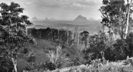
 Looking across Wootha towards the Glass House Mountains, circa 1931 Looking across Wootha towards the Glass House Mountains, circa 1931 | |||||||||||||||
 | |||||||||||||||
| Coordinates | 26°47′15″S 152°48′01″E / 26.7875°S 152.8002°E / -26.7875; 152.8002 (Wootha (centre of locality)) | ||||||||||||||
| Population | 258 (2021 census) | ||||||||||||||
| • Density | 16.02/km (41.50/sq mi) | ||||||||||||||
| Postcode(s) | 4552 | ||||||||||||||
| Area | 16.1 km (6.2 sq mi) | ||||||||||||||
| Time zone | AEST (UTC+10:00) | ||||||||||||||
| Location | |||||||||||||||
| LGA(s) | Sunshine Coast Region | ||||||||||||||
| State electorate(s) | Glass House | ||||||||||||||
| Federal division(s) | Fisher | ||||||||||||||
| |||||||||||||||
Wootha is a rural locality in the Sunshine Coast Region, Queensland, Australia. In the 2021 census, Wootha had a population of 258 people.
History
The name Wootha comes from the Kabi language (Dallambara dialect) meaning red cedar tree.
Blackall Range Provisional School opened on 18 October 1886 in a building constructed by Mr J. McCarthy on his own land. The first teacher was William Verrant. After a few years, the school building was relocated to land belonging to Mr R. Johnston. In 1900, it was relocated to its permanent site in Wootha at 369 Maleny-Stanley River Road (26°46′55″S 152°49′18″E / 26.78186°S 152.82153°E / -26.78186; 152.82153 (Wootha State School (former))). It became Blackall Range State School on 1 October 1909. A new school building was constructed circa 1912. It was officially renamed Wootha State School in 1937, although the name had been in informal use for some time. It closed circa 29 April 1949 with transport being provided so the children could attend Maleny State school. In 1950, the Wootha school building was relocated to Palmwoods State School to provide an additional building.
Demographics
In the 2016 census,Wootha had a population of 201 people.
In the 2021 census, Wootha had a population of 258 people.
Education
There are no schools in Wootha. The nearest government primary and secondary schools are Maleny State School and Maleny State High School respectively, both in neighbouring Maleny to the north-east.
Amenities
There are a number of parks in the area:
- Maleny-Stanley River Road Park (26°46′47″S 152°49′59″E / 26.7796°S 152.8330°E / -26.7796; 152.8330 (Maleny-Stanley River Road Park - Wootha))
- Policeman Spur Environmental Reserve (26°48′01″S 152°46′54″E / 26.8002°S 152.7817°E / -26.8002; 152.7817 (Policeman Spur Environmental Reserve))
Attractions

Despite its name, Maleny Botanic Gardens and Bird World is at 233 Maleny Stanley River Road in Wootha (26°46′48″S 152°50′05″E / 26.7800°S 152.8346°E / -26.7800; 152.8346 (Maleny Botanic Gardens and Bird World)).
See also
References
- ^ Australian Bureau of Statistics (28 June 2022). "Wootha (SAL)". 2021 Census QuickStats. Retrieved 28 February 2023.

- ^ "Wootha – locality in Sunshine Coast Region (entry 48944)". Queensland Place Names. Queensland Government. Retrieved 29 December 2020.
- "SCHOOL JUBILEE AT WOOTHA". Sunday Mail. No. 340. Queensland, Australia. 25 October 1936. p. 8. Retrieved 17 November 2024 – via National Library of Australia.
- "Glasshouse" (Map). Queensland Government. 1942. Archived from the original on 21 September 2024. Retrieved 17 November 2024.
- "Queensland Two Mile series sheet 2m74" (Map). Queensland Government. 1949. Retrieved 17 November 2024.
- "STATE SCHOOLS". The Brisbane Courier. Vol. LXVI, no. 16, 132. Queensland, Australia. 24 September 1909. p. 7. Retrieved 17 November 2024 – via National Library of Australia.
- "Mr. Harry Walker". Gympie Times And Mary River Mining Gazette. Vol. XLV, no. 5909. Queensland, Australia. 23 April 1912. p. 4. Retrieved 17 November 2024 – via National Library of Australia.
- Queensland Family History Society (2010), Queensland schools past and present (Version 1.01 ed.), Queensland Family History Society, ISBN 978-1-921171-26-0
- "Agency ID 9289, Wootha State School". Queensland State Archives. Retrieved 17 November 2024.
- "Advertising". Nambour Chronicle And North Coast Advertiser. No. 2502. Queensland, Australia. 16 May 1952. p. 7. Retrieved 17 November 2024 – via National Library of Australia.
- "MALENY". Nambour Chronicle And North Coast Advertiser. No. 2422. Queensland, Australia. 17 November 1950. p. 5. Retrieved 17 November 2024 – via National Library of Australia.
- "A Ride to School Maleny 1910". Maleny District Sport and Recreation Club Inc. 21 January 2021. Archived from the original on 22 October 2024. Retrieved 16 November 2024.
- Australian Bureau of Statistics (27 June 2017). "Wootha (SSC)". 2016 Census QuickStats. Retrieved 20 October 2018.

- "Layers: Locality; Schools and school catchments". Queensland Globe. Queensland Government. Archived from the original on 19 December 2017. Retrieved 16 November 2024.
- ^ "Land for public recreation - Queensland". Queensland Open Data. Queensland Government. 20 November 2020. Archived from the original on 22 November 2020. Retrieved 22 November 2020.
- "Maleny Botanic Gardens & Bird World". – Maleny Botanic Gardens & Bird World. Archived from the original on 29 December 2020. Retrieved 28 February 2021.
Further reading
- Maleny schools' centenary celebration : 100 years of education, 1913-2013, Maleny P&C, 2013 — includes Blackall Range State School