| Sinhua 新化區Shinka; Sin-Hua | |
|---|---|
| District | |
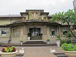
 Japanese-era Town Government Hall Japanese-era Town Government Hall | |
 Sinhua District in Tainan City Sinhua District in Tainan City | |
| Location | Tainan, Taiwan |
| Area | |
| • Total | 62 km (24 sq mi) |
| Population | |
| • Total | 42,514 |
| • Density | 690/km (1,800/sq mi) |
| Website | web |


| Sinhua District | |||||||||||||||
|---|---|---|---|---|---|---|---|---|---|---|---|---|---|---|---|
| Chinese | 新化區 | ||||||||||||||
| |||||||||||||||
Sinhua District (Chinese: 新化區; Hanyu Pinyin: Xīnhuà Qū; Tongyong Pinyin: Sinhuà Cyu; Wade–Giles: Hsin-hua Ch'ü), alternatively spelled Xinhua, is a suburban district in central Tainan, Taiwan.
History
Before the Dutch and Han Chinese invaded, this region was home to a community of Taiwanese aborigines, the Siraya. In 1624, the VOC occupied Tayuan (modern day Anping, Tainan).
In the past, the Siraya indigenous tribe called this place Tavocan ("land of hill and forest"). Tavakan was a village of about a thousand people; the name was also written Taffacan, Tavocan, Tavacang, and Davocan in Dutch records. The village grew into the market-town of Twa-bak-kang (Chinese: 大目降; Pe̍h-ōe-jī: Tōa-ba̍k-kàng), about 2 miles (3.2 km) southeast of Sin-kang (modern-day Sinshih).
After 1627, the VOC sent missionaries into neighboring districts. In 1635, George Candidius, a Dutch pastor, advised Pieter Nuyts, the leader of the Dutch VOC in Taiwan, that the VOC would have to conquer the aborigines before they could be controlled. In 1636, eighteen tribal groups, including the inhabitants of Tavocan, submitted to Dutch rule.

Since the early part of the 20th century, Sinhua has been an important fruit wholesaling center. Around 1920, dozens of baroque-influenced store buildings were constructed along what is now Jhongjheng Road. Most of these buildings survive in good condition, and the street, known as "Sinhua Old Street," has become a tourist attraction.
In 1945, Sinshih Township was part of Sinhua District.

The Taiwan Communist Party was established on 20 June 2008 in Sinhua.
Geography
- Area: 62.06 km
- Population: 43,830 people (January 2016)
Much of the district is rural, with large areas devoted to pineapple cultivation. Sinhua is located on Taiwan Highway No. 20, also known as the Southern Cross-Island Highway, and Freeway Nos. 3 and 8. It borders Yongkang, Shanshang, Sinshih and Guanmiao districts.
The eastern half of the district lies within the Siraya National Scenic Area.
Administrative divisions
The district consists of Wu-An/Wuan, Dong-Rong/Tungrong, Hu-Guo/Huguo, Tai-Ping/Taiping, Sie-Sing/Xiexing, Fong-Kou/Fengkou, Bei-Shih/Beishi, Fong-Rong/Fengrong, Cyan-Sing/Quanxing, Lun-Ding/Lunding, Jhih-Yi/Zhiyi, Shan-Jiao/Shanjiao, Da-Keng/Dakeng, Na-Ba/Naba, Yang-Lin/Xianglin, Jiao-Keng/Jiaokeng Village.
Institutions
Education
Special School
Senior High Schools
Junior high schools
Tourist attractions
Transportation

The Sinhua Bus Station is located in the district. The district is connected to Kaohsiung at Alian District through the Provincial Highway 39.
The Taiwan High Speed Rail track passes through the western part of the district; no station is planned, however.
Notable natives
See also
References
- "District Office". Tainan City Government Global Website. 2016-06-03. Retrieved 24 July 2019.
Sinhua District Office
- "Introducing Sinhua". SIN-HUA District Office, Tainan City. Retrieved 24 July 2019.
Sinhua District in Tainan City was once called Davocan and was a part of the Singangshe Siraya settlement of the Pingpu People.
- ^ "About us INTRODUCING THE DISTRICT OFFICE". Sinshih District Office, Tainan City. Retrieved 25 July 2019.
After the retrocession of Taiwan in 1945, the Nationalist (Guomindang) Government adjusted the administra- tive divisions, changing the Cho to Sian (counties), Ken to Cyu (districts), and Sho to Siang (towns). This was when Sinshih Township was created. The full administrative name of the place was Sinshih Township, Sinhua District, Tainan County.
- Sinhua (Variant - V) at GEOnet Names Server, United States National Geospatial-Intelligence Agency
- "2019 Tainan May Jam to take place at Hutoupi in SW Taiwan on May 4 - 5". Taiwan News. 2019-04-24. Retrieved 24 July 2019.
The 2019 Tainan May Jam will take place at Hutoupi Scenic Area (虎頭埤風景區) in Sinhua (新化), Tainan City from 12 p.m. to 10 p.m. on May 4 – 5, and there will be 30 bands performing in the concert this year, Tainan's Tourism Bureau said on Tuesday.
- Campbell, William (1903). "Explanatory Notes". Formosa under the Dutch: described from contemporary records, with explanatory notes and a bibliography of the island. London: Kegan Paul. p. 548. ISBN 9789576380839. OCLC 644323041.
- "Entry #40013 (大目降)". 臺灣閩南語常用詞辭典 [Dictionary of Frequently-Used Taiwan Minnan]. (in Chinese and Hokkien). Ministry of Education, R.O.C. 2011.
- 台灣共產黨申請14年後獲准成立 (in Chinese). BBC Chinese.com. 21 July 2008. Archived from the original on 27 January 2018. Retrieved 23 July 2008.
- "2018 Local Elections". Archived from the original on 2018-12-05.
- "Sin Hua District Disaster Prevention Map". SIN-HUA District Office, Tainan City. 7 May 2018. Retrieved 25 July 2019.
Date Subject 2017-08-31 Jhih-Yi Village Disaster Prevention Map 2017-06-23 Tai-Ping Village Disaster Prevention Map 2017-06-23 Yang-Lin Village Disaster Prevention Map 2017-06-23 Na-Ba Village Disaster Prevention Map 2017-06-23 Da-Keng Village Disaster Prevention Map 2017-06-23 Shan-Jiao Village Disaster Prevention Map 2017-06-23 Hu-Guo Village Disaster Prevention Map 2017-06-23 Jiao-Keng Village Disaster Prevention Map 2017-06-23 Dong-Rong Village Disaster Prevention Map 2017-06-23 Wu-An Village Disaster Prevention Map 2017-06-23 Cyuan-Sing Village Disaster Prevention Map 2017-06-23 Lun-Ding Village Disaster Prevention Map 2017-06-23 Fong-Rong Village Disaster Prevention Map 2017-06-23 Bei-Shih Village Disaster Prevention Map 2017-06-23 Fong-Kou Village Disaster Prevention Map 2017-06-23 Sie-Sing Village Disaster Prevention Map
External links
| Districts in Taiwan | |||||||||||||
|---|---|---|---|---|---|---|---|---|---|---|---|---|---|
| List of townships/cities and districts in Taiwan | |||||||||||||
| Special municipalities |
| ||||||||||||
| Cities |
| ||||||||||||
| ¹ — Mountain indigenous district | |||||||||||||
23°2′18″N 120°18′39″E / 23.03833°N 120.31083°E / 23.03833; 120.31083