| This article needs additional citations for verification. Please help improve this article by adding citations to reliable sources. Unsourced material may be challenged and removed. Find sources: "Yambrasbamba District" – news · newspapers · books · scholar · JSTOR (November 2014) (Learn how and when to remove this message) |
| Yambrasbamba | |
|---|---|
| District | |
 Yambrasbamba District Yambrasbamba District | |
| Country | |
| Region | Amazonas |
| Province | Bongará |
| Time zone | UTC-5 (PET) |
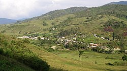
Yambrasbamba is a district of Bongará Province in Peru. The district occupies an area of 1.715,96 km. It was created on December 26, 1870, and has a population of approximately 12,000 inhabitants. The capital of the district is the city of Yambrasbamba, at an elevation of 1,903 meters on above sea level. The city has an attractive ambience with varieties of orchids and large trees. It is crossed by the Imaza River. The population of the district is primarily rural and of mixed origin. The population devotes themselves to raising cattle, to the production of milk and to the culture of yacón, corn, carrots, swallows and coffee.
Principal attractions
- The Hope. A Hydroelectric project that provides power to the district.
- El Progreso
See also
References
- "Provincias y Distritos". Gobierno Regional de Amazonas (in Spanish). n.d. Archived from the original on 15 June 2013. Retrieved 15 November 2014.
External links
| |
|---|---|
| Bagua | |
| Bongará | |
| Chachapoyas | |
| Condorcanqui | |
| Luya | |
| Rodríguez de Mendoza | |
| Utcubamba | |
5°45′S 77°54′W / 5.750°S 77.900°W / -5.750; -77.900
This Amazonas geography article is a stub. You can help Misplaced Pages by expanding it. |