| Yozgat District | |
|---|---|
| District | |
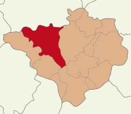
 Map showing Yozgat District in Yozgat Province Map showing Yozgat District in Yozgat Province | |
  | |
| Coordinates: 39°49′N 34°49′E / 39.817°N 34.817°E / 39.817; 34.817 | |
| Country | Turkey |
| Province | Yozgat |
| Seat | Yozgat |
| Area | 2,024 km (781 sq mi) |
| Population | 109,197 |
| • Density | 54/km (140/sq mi) |
| Time zone | UTC+3 (TRT) |
Yozgat District (also: Merkez, meaning "central" in Turkish) is a district of the Yozgat Province of Turkey. Its seat is the city of Yozgat. Its area is 2,024 km, and its population is 109,197 (2022).
Composition
There is one municipality in Yozgat District:
There are 96 villages in Yozgat District:
- Aktaş
- Akyamaç
- Alemdar
- Aydoğan
- Azizli
- Bacılı
- Bahçecik
- Baltasarılar
- Başıbüyüklü
- Başınayayla
- Battal
- Bayatören
- Beyvelioğlu
- Bişek
- Bozlar
- Büyükincirli
- Büyükmahal
- Büyüknefes
- Buzağcıoğlu
- Çadırardıç
- Çağlayan
- Çalatlı
- Çalılı
- Çatma
- Cihanpaşa
- Çorak
- Dağyenicesi
- Dambasan
- Darıcı
- Dayılı
- Delihasanlı
- Derbent
- Dereboymul
- Derekışla
- Deremahal
- Deremumlu
- Erkekli
- Esenli
- Evci
- Fakıbeyli
- Gevrek
- Gökçekışla
- Güdülelmahacılı
- Güllük
- Güllüoluk
- Gülyayla
- Güneşli
- Hamzalı
- Haydarbeyli
- İnceçayır
- İşleğen
- Kababel
- Kaleköy
- Karabıyık
- Karacalar
- Karalar
- Kaşkışla
- Kavurgalı
- Kırıksoku
- Kırım
- Kışlaköy
- Kızıltepe
- Köçekkömü
- Köçeklioğlu
- Kolanlı
- Körpeli
- Köseyusuflu
- Koyunculu
- Kuşçu
- Kuyumcu
- Lökköy
- Mezraa
- Musabeyli
- Musabeyliboğazı
- Örencik
- Osmanpaşa
- Özlüce
- Pembecik
- Recepli
- Sağlık
- Salmanfakılı
- Sarıfatma
- Sarımbey
- Sarınınören
- Söğütyayla
- Tayfur
- Tayip
- Tekkeyenicesi
- Topaç
- Topçu
- Türkmen
- Türkmensarılar
- Yassıhüyük
- Yazpınarı
- Yeşilova
- Yudan
References
- ^ İl Belediyesi, Turkey Civil Administration Departments Inventory. Retrieved 22 May 2023.
- "İl ve İlçe Yüz ölçümleri". General Directorate of Mapping. Retrieved 22 May 2023.
- "Address-based population registration system (ADNKS) results dated 31 December 2022, Favorite Reports" (XLS). TÜİK. Retrieved 22 May 2023.
- Köy, Turkey Civil Administration Departments Inventory. Retrieved 22 May 2023.
| Yozgat District in Yozgat Province of Turkey | ||
|---|---|---|
| Districts |  | |
| Metropolitan municipalities are bolded. | ||
This geographical article about a location in Yozgat Province, Turkey is a stub. You can help Misplaced Pages by expanding it. |
