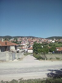
| Yukarıkaşıkara | |
|---|---|
| Village | |
 A view of the village. A view of the village. | |
 | |
| Coordinates: 38°20′44″N 30°52′01″E / 38.34556°N 30.86694°E / 38.34556; 30.86694 | |
| Country | Turkey |
| Province | Isparta |
| District | Yalvaç |
| Elevation | 1,276 m (4,186 ft) |
| Population | 1,116 |
| Time zone | UTC+3 (TRT) |
| Postal code | 32400 |
| Area code | 0246 |
Yukarıkaşıkara, also known as Yukarı Kaşıkara, is a village in the Yalvaç District, Isparta Province, Turkey. Its population is 1,116 (2022). Before the 2013 reorganisation, it was a town (belde).
History
The village has had the same name since 1928. It became a municipality on December 17, 1986. However, the municipality status of the town ended in 2013 due to the population dropping below 2,000.
Geography
The village is located 100 km away from the center of Isparta and 38 km away from the center of Yalvaç.
Demographics
| Year | Pop. | ±% p.a. |
|---|---|---|
| 1990 | 2,244 | — |
| 1997 | 2,432 | +1.16% |
| 2007 | 1,805 | −2.94% |
| 2012 | 1,900 | +1.03% |
| 2017 | 1,218 | −8.51% |
| 2022 | 1,116 | −1.73% |
| Source: 1990 census, 1997 census and TÜIK (2007-2022) | ||
Gallery
References
- "Yukarikasikara, Turkey Page". Fallingrain.com. Archived from the original on 6 July 2020. Retrieved 7 July 2020.
- ^ "Population Of Municipalities, Villages And Quarters". TÜIK. Retrieved 18 July 2023.
- Köy, Turkey Civil Administration Departments Inventory. Retrieved 22 May 2023.
- Law No. 6360, Official Gazette, 6 December 2012 (in Turkish).
- Nişanyan, Sevan. "Yukarıkaşıkara". Index-Anatolicus: Türkiye yerleşim birimleri envanteri. nisanyanmap.com.
- "Belediye Kurulmasına Dair Kararlar" (PDF) (in Turkish). Resmî Gazete. 29 December 1986. Archived from the original (PDF) on 4 May 2021. Retrieved 4 May 2021.
- "İşte Kapatılacak 559 Belde !". kamudan.com. 10 October 2012. Archived from the original on 27 October 2018. Retrieved 15 May 2020.
- "1990 General Census" (PDF) (in Turkish). Turkish Statistical Institute. 1991. Archived (PDF) from the original on 31 August 2021.
- "1997 Population Count" (PDF) (in Turkish). Turkish Statistical Institute. 1999. Archived (PDF) from the original on 30 October 2022.
| Municipalities | |
|---|---|
| Villages |
|
This article about a Mediterranean Region of Turkey location is a stub. You can help Misplaced Pages by expanding it. |
