| Zamostec | |
|---|---|
 | |
 | |
| Coordinates: 45°45′25.76″N 14°38′53.4″E / 45.7571556°N 14.648167°E / 45.7571556; 14.648167 | |
| Country | |
| Traditional region | Lower Carniola |
| Statistical region | Southeast Slovenia |
| Municipality | Sodražica |
| Area | |
| • Total | 4.46 km (1.72 sq mi) |
| Elevation | 530.1 m (1,739.2 ft) |
| Population | |
| • Total | 209 |
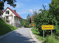
Zamostec (pronounced [zaˈmoːstəts] or [zamɔˈstəts]; German: Brückel) is a settlement east of Sodražica in southern Slovenia. The area is part of the traditional region of Lower Carniola and is now included in the Southeast Slovenia Statistical Region. The settlement includes the hamlets of Vranove Njivice, Podgora, Mandrge, Podvas, Grdi Dol (German: Gerdido), and Bravčji Vrt.
Name
Zamostec was attested in historical sources as Pruͤklein in 1343 and Prukchlein in 1444, among other spellings.
Cultural heritage
A small chapel-shrine in the village is dedicated to the Our Lady of the Snows. It was built in the late 19th century.
References
- Statistical Office of the Republic of Slovenia Archived November 18, 2008, at the Wayback Machine
- ^ Leksikon občin kraljestev in dežel zastopanih v državnem zboru, vol. 6: Kranjsko. 1906. Vienna: C. Kr. Dvorna in Državna Tiskarna, pp. 50–51.
- Sodražica municipal site
- Savnik, Roman, ed. 1971. Krajevni leksikon Slovenije, vol. 2. Ljubljana: Državna založba Slovenije, p. 579.
- "Zamostec". Slovenska historična topografija. ZRC SAZU Zgodovinski inštitut Milka Kosa. Retrieved August 20, 2020.
- Slovenian Ministry of Culture register of national heritage Archived July 12, 2010, at the Wayback Machine reference number ešd 22409
External links
 Media related to Zamostec at Wikimedia Commons
- Zamostec on Geopedia
| Municipality of Sodražica | ||||||
|---|---|---|---|---|---|---|
| Settlements | Administrative seat: Sodražica
|  | ||||
| Landmarks | ||||||
This article about the Municipality of Sodražica in Slovenia is a stub. You can help Misplaced Pages by expanding it. |