| Zavalje Заваље | |
|---|---|
| Village | |
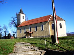
 Catholic church in Zavalje Catholic church in Zavalje | |
 | |
| Coordinates: 44°47′N 15°51′E / 44.783°N 15.850°E / 44.783; 15.850 | |
| Country | |
| Entity | Federation of Bosnia and Herzegovina |
| Canton | |
| Municipality | |
| Area | |
| • Total | 9.63 sq mi (24.93 km) |
| Population | |
| • Total | 72 |
| • Density | 7.5/sq mi (2.9/km) |
| Time zone | UTC+1 (CET) |
| • Summer (DST) | UTC+2 (CEST) |
Zavalje (Serbian Cyrillic: Заваље) is a village in the municipality of Bihać, Bosnia and Herzegovina.
Before World War I, Zavalje was part of the Kingdom of Croatia-Slavonia of Austria-Hungary. It became part of the Vrbas Banovina of the Kingdom of Yugoslavia in 1931, and subsequently became part of SR Bosnia and Herzegovina in SFR Yugoslavia.
Demographics
According to the 2013 census, its population was 72.
| Ethnicity | Number | Percentage |
|---|---|---|
| Croats | 58 | 80.6% |
| Bosniaks | 8 | 11.1% |
| Serbs | 1 | 1.4% |
| other/undeclared | 5 | 6.9% |
| Total | 72 | 100% |
References
- Official results from the book: Ethnic composition of Bosnia-Herzegovina population, by municipalities and settlements, 1991. census, Zavod za statistiku Bosne i Hercegovine - Bilten no.234, Sarajevo 1991.
- "Naseljena Mjesta 1991/2013" (in Bosnian). Statistical Office of Bosnia and Herzegovina. Retrieved August 4, 2021.
44°47′N 15°51′E / 44.783°N 15.850°E / 44.783; 15.850
This Una-Sana Canton geography article is a stub. You can help Misplaced Pages by expanding it. |