| This article needs additional citations for verification. Please help improve this article by adding citations to reliable sources. Unsourced material may be challenged and removed. Find sources: "Zuurbekom" – news · newspapers · books · scholar · JSTOR (September 2014) (Learn how and when to remove this message) |
| Zuurbekom | |
|---|---|
  | |
| Coordinates: 26°18′00″S 27°47′00″E / 26.3000°S 27.7833°E / -26.3000; 27.7833 | |
| Country | South Africa |
| Province | Gauteng |
| District | West Rand |
| Municipality | Rand West City |
| Population | |
| • Total | 3,449 |
| Time zone | UTC+2 (SAST) |
| Area code | 011 |
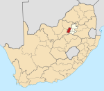
Zuurbekom is a town in the Gauteng province, South Africa. It is mainly earmarked for agricultural purposes.
References
- Water Services National Information System - Community Report
- "History of Council". Westonaria Local Municipality. Retrieved 27 January 2014.
| Municipalities and communities of West Rand District Municipality, Gauteng | ||
|---|---|---|
| District seat: Randfontein | ||
| Mogale City |  | |
| Merafong City | ||
| Rand West City | ||
This Gauteng location article is a stub. You can help Misplaced Pages by expanding it. |