Unincorporated community in Kansas, United States
| Zyba, Kansas | |
|---|---|
| Unincorporated community | |
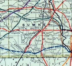
 1915 Railroad Map of Sumner County 1915 Railroad Map of Sumner County | |
 KDOT map of Sumner County (legend) KDOT map of Sumner County (legend) | |
  | |
| Coordinates: 37°26′05″N 97°23′21″W / 37.43472°N 97.38917°W / 37.43472; -97.38917 | |
| Country | United States |
| State | Kansas |
| County | Sumner |
| Elevation | 1,230 ft (370 m) |
| Time zone | UTC-6 (CST) |
| • Summer (DST) | UTC-5 (CDT) |
| Area code | 620 |
| FIPS code | 20-81050 |
| GNIS ID | 484508 |
Zyba is an unincorporated community in Sumner County, Kansas, United States. It is located about 4 miles southwest of the Kansas Star Casino at N West St and E 120th Ave N, next to the railroad and Ninnescah River.
History
A post office was opened in Zyba in 1887, and remained in operation until it was discontinued in 1906.
Education
The community is served by Belle Plaine USD 357 public school district.
References
- ^ "Zyba, Kansas", Geographic Names Information System, United States Geological Survey, United States Department of the Interior
- "Kansas Post Offices, 1828-1961, page 2". Kansas Historical Society. Retrieved June 27, 2014.
Further reading
See also: List of books about Sumner County, KansasExternal links
- Sumner County map, KDOT
| Municipalities and communities of Sumner County, Kansas, United States | ||
|---|---|---|
| County seat: Wellington | ||
| Cities |  | |
| CDPs | ||
| Unincorporated communities | ||
| Ghost town | ||
| Townships |
| |
| Footnotes | ‡This community also has portions in an adjacent county or counties. | |