| Revision as of 19:22, 31 May 2015 editIvanOS (talk | contribs)3,333 edits Reverted aggressive edit which violates deal. Minority name in lede is more than enough.← Previous edit | Latest revision as of 20:24, 15 September 2024 edit undoJJMC89 bot III (talk | contribs)Bots, Administrators3,690,550 editsm Moving Category:Populated places in Vukovar-Syrmia County to Category:Populated places in Vukovar-Srijem County per Misplaced Pages:Categories for discussion/Speedy | ||
| (36 intermediate revisions by 14 users not shown) | |||
| Line 1: | Line 1: | ||
| {{Infobox settlement | {{Infobox settlement | ||
| |name = Mikluševci | | name = Mikluševci | ||
| | native_name = {{native name|rue|Миклошевци|italics=off}}<ref name="Prijedlog izvještaja">{{cite web|url=https://www.coe.int/t/dg4/education/minlang/Report/PeriodicalReports/CroatiaPR5_hr.pdf | title=Peto izvješće Republike Hrvatske o primjeni Europske povelje o regionalnim ili manjinskim jezicima | date=October 2013 | author=Government of Croatia | publisher=] | page=36 | language=hr | format=PDF | accessdate=2 December 2016}}</ref> | |||
| ⚫ | | pushpin_label = Mikluševci | ||
| |other_name |
| other_name = | ||
| | settlement_type = ] (]) | |||
| ⚫ | | |
||
| | image_skyline = Mikluševci Миклошевци Миклушевци.png | |||
| |settlement_type = Village | |||
| | |
| imagesize = | ||
| | |
| image_caption = | ||
| | |
| image_flag = | ||
| | |
| flag_size = | ||
| | |
| image_seal = | ||
| | |
| seal_size = | ||
| | |
| nickname = | ||
| | |
| motto = | ||
| |image_map |
| image_map = Mikluševci.png | ||
| |mapsize |
| mapsize = | ||
| |map_caption |
| map_caption = | ||
| |pushpin_map |
| pushpin_map = Croatia Vukovar-Srijem County#Croatia#Europe | ||
| ⚫ | | pushpin_mapsize = | ||
| ⚫ | |pushpin_label_position = |
||
| ⚫ | | pushpin_map_caption = Location in Croatia | ||
| ⚫ | |pushpin_mapsize= | ||
| ⚫ | | pushpin_label = Mikluševci | ||
| ⚫ | |pushpin_map_caption |
||
| ⚫ | | pushpin_label_position = left | ||
| |subdivision_type = Country | |||
| ⚫ | | coordinates = {{coord|45|15|05|N|19|05|05|E|display=inline,title|region:HR_type:city}} | ||
| ⚫ | |subdivision_name |
||
| | |
| subdivision_type = ] | ||
| ⚫ | | subdivision_name = {{flag|Croatia}} | ||
| ⚫ | |subdivision_name1 |
||
| | |
| subdivision_type1 = ] | ||
| ⚫ | | subdivision_name1 = ] (]) | ||
| |subdivision_name2 = | |||
| | subdivision_type2 = ] | |||
| ⚫ | |government_footnotes |
||
| | subdivision_name2 = {{flag|Vukovar-Srijem|name=Vukovar-Syrmia}} | |||
| ⚫ | |government_type |
||
| | subdivision_type3 = ] | |||
| ⚫ | | |
||
| | subdivision_name3 = ] | |||
| ⚫ | | |
||
| |established_title |
| established_title = | ||
| |established_date |
| established_date = | ||
| ⚫ | | government_footnotes = | ||
| ⚫ | | |
||
| ⚫ | | government_type = | ||
| |unit_pref = Imperial | |||
| | |
| leader_title = | ||
| | |
| leader_name = | ||
| | |
| unit_pref = Imperial | ||
| | area_footnotes = <ref>{{Cite Q|Q119585703|mode=cs1}}</ref> | |||
| ⚫ | |population_as_of |
||
| | area_total_km2 = 11.5 | |||
| |population_footnotes = | |||
| | |
| area_land_km2 = | ||
| ⚫ | | elevation_footnotes = | ||
| ⚫ | |population_total |
||
| | |
| elevation_m = | ||
| ⚫ | | elevation_ft = | ||
| ⚫ | | |
||
| | population_footnotes = <ref name="Census 2021">{{Croatian Census 2021|S}}</ref> | |||
| |utc_offset = +1 | |||
| ⚫ | | population_as_of = 2021 | ||
| |timezone_DST = ] | |||
| ⚫ | | population_total = 265 | ||
| |utc_offset_DST = +2 | |||
| | population_density_km2 = auto | |||
| |latd=|latm=|lats= |latNS=N | |||
| | population_urban = | |||
| |longd=|longm=|longs=|longEW=E | |||
| | population_density_urban_km2 = | |||
| ⚫ | |elevation_footnotes |
||
| | |
| population_note = | ||
| | population_demonym = Mikluševčanin (]) Mikluševčanka (])<br /> | |||
| ⚫ | |elevation_ft |
||
| <small>(per ])</small> | |||
| ⚫ | |postal_code_type |
||
| | |
| timezone = ] | ||
| ⚫ | | timezone_DST = ] | ||
| |area_code = | |||
| | |
| utc_offset = +1 | ||
| | |
| utc_offset_DST = +2 | ||
| ⚫ | | postal_code_type = | ||
| |website = | |||
| | |
| postal_code = | ||
| ⚫ | | area_code = | ||
| ⚫ | | blank_name = | ||
| | blank_info = | |||
| ⚫ | | website = | ||
| ⚫ | | footnotes = | ||
| }} | }} | ||
| '''Mikluševci''' (]: Миклошевци)<ref name="Minority names">{{cite web|url=http://www.nipp.hr/UserDocsImages/Registar%20geografska%20imena%20nacionalnih%20manjina%20RH.pdf|title=Minority names in Croatia:Registar Geografskih Imena Nacionalnih Manjina Republike Hrvatske |format=PDF |
'''Mikluševci''' (]: Миклошевци)<ref name="Minority names">{{cite web|url=http://www.nipp.hr/UserDocsImages/Registar%20geografska%20imena%20nacionalnih%20manjina%20RH.pdf |title=Minority names in Croatia:Registar Geografskih Imena Nacionalnih Manjina Republike Hrvatske |format=PDF |accessdate=2013-03-08 |url-status=dead |archiveurl=https://web.archive.org/web/20131029211333/http://www.nipp.hr/UserDocsImages/Registar%20geografska%20imena%20nacionalnih%20manjina%20RH.pdf |archivedate=2013-10-29 }}</ref> is a ] in ]. | ||
| ==Name== | |||
| ⚫ | During the ], the ] forces captured the village on 8 October 1991. Following the capture of the village, a family of three was killed by the Croatian Serb forces in the nearby Jelaš Forest, and 92 were expelled. A total of 35 persons were charged with the killings in 1996 by Croatian authorities in ]. By 2009, when the trial had concluded, eleven defendants died, and charges against ten were dropped. Twelve were convicted to prison sentences ranging from four to fifteen years and two were acquitted. Most of the defendants were ]—only three defendants were present at the sentencing.<ref>{{cite news|newspaper=]|url=http://www.slobodnadalmacija.hr/Hrvatska/tabid/66/articleType/ArticleView/articleId/40936/Default.aspx|language=Croatian|title=Presuda za ratni zločin: Mikluševačkoj skupini ukupno 83 godine| |
||
| The name of the village in ] is plural. Other than Croatian and Pannonian Rusyn the village is known as Миклушевци in ], ''Szentmiklós'' in ] and ''Sankt Niklas'' in ]. | |||
| ==History== | |||
| It is assumed, but there are no preserved documents, that Mikluševci existed as an independent noble estate before ] rule. Mikluševci were under Turkish rule between 1526 and 1691, when all villages from this area were displaced. After liberation from the ], ] ] settled in Mikluševci first, after 1700, and later refugees from ], and in the middle of the 19th century, ]. According to the population census from 1880, Mikluševci had 712 inhabitants, of which 467 were ], 227 ], 11 ] and 7 ]. <ref>{{Cite web |title=Naselja Općine – Općina Tompojevci |url=https://www.opcina-tompojevci.hr/upoznajte-opcinu/naselja-opcine/ |access-date=2023-01-18 |language=hr}}</ref> | |||
| ⚫ | During the ], the ] forces captured the village on 8 October 1991. Following the capture of the village, a family of three was killed by the Croatian Serb forces in the nearby Jelaš Forest, and 92 were expelled. A total of 35 persons were charged with the killings in 1996 by Croatian authorities in ]. By 2009, when the trial had concluded, eleven defendants died, and charges against ten were dropped. Twelve were convicted to prison sentences ranging from four to fifteen years and two were acquitted. Most of the defendants were ]—only three defendants were present at the sentencing.<ref>{{cite news|newspaper=]|url=http://www.slobodnadalmacija.hr/Hrvatska/tabid/66/articleType/ArticleView/articleId/40936/Default.aspx|language=Croatian|title=Presuda za ratni zločin: Mikluševačkoj skupini ukupno 83 godine|trans-title=War Crime Verdict: Mikluševci Group Sentenced to Total of 83 Years|first=Mladen|last=Obrenović|date=5 February 2009}}</ref> | ||
| <gallery> | |||
| Image:Eastern Catholic Church in Mikluševci Миклошевци.JPG|Greek Catholic ] | |||
| Image:Oil station in Mikluševci Миклошевци.JPG|Oil station | |||
| Image:Eastern Orthodox Cemetery in Mikluševci Миклошевци.JPG|Eastern Orthodox Cemetery | |||
| Image:WWII monument in Mikluševci Миклошевци.JPG|World War II monument | |||
| Image:Serbian Orthodox Church in Mikluševci Миклошевци.JPG|] ] | |||
| </gallery> | |||
| ==References== | ==References== | ||
| {{commons category|Mikluševci}} | |||
| {{Reflist}} | {{Reflist}} | ||
| {{Tompojevci Municipality}} | |||
| ⚫ | {{coord|45|15|N|19|05|E|display=title|region:HR_type: |
||
| {{Villages of Vukovar-Syrmia County}} | |||
| {{DEFAULTSORT:Miklusevci}} | {{DEFAULTSORT:Miklusevci}} | ||
| ] | ] | ||
| ] | ] | ||
| ] | ] | ||
| {{VukovarSyrmia-geo-stub}} | {{VukovarSyrmia-geo-stub}} | ||
Latest revision as of 20:24, 15 September 2024
Village in Syrmia, Croatia| Mikluševci Миклошевци (Rusyn) | |
|---|---|
| Village (Selo) | |
 | |
 | |
   | |
| Coordinates: 45°15′05″N 19°05′05″E / 45.25139°N 19.08472°E / 45.25139; 19.08472 | |
| Country | |
| Region | Syrmia (Podunavlje) |
| County | |
| Municipality | Tompojevci |
| Area | |
| • Total | 4.4 sq mi (11.5 km) |
| Population | |
| • Total | 265 |
| • Density | 60/sq mi (23/km) |
| Demonym(s) | Mikluševčanin (♂) Mikluševčanka (♀) (per grammatical gender) |
| Time zone | UTC+1 (CET) |
| • Summer (DST) | UTC+2 (CEST) |
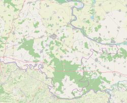
Mikluševci (Rusyn: Миклошевци) is a village in Croatia.
Name
The name of the village in Croatian is plural. Other than Croatian and Pannonian Rusyn the village is known as Миклушевци in Serbian, Szentmiklós in Hungarian and Sankt Niklas in German.
History
It is assumed, but there are no preserved documents, that Mikluševci existed as an independent noble estate before Turkish rule. Mikluševci were under Turkish rule between 1526 and 1691, when all villages from this area were displaced. After liberation from the Turks, Orthodox Vlachs settled in Mikluševci first, after 1700, and later refugees from Baranja, and in the middle of the 19th century, Ruthenians. According to the population census from 1880, Mikluševci had 712 inhabitants, of which 467 were Greek Catholics, 227 Orthodox, 11 Roman Catholics and 7 Jews.
During the Croatian War of Independence, the Croatian Serb forces captured the village on 8 October 1991. Following the capture of the village, a family of three was killed by the Croatian Serb forces in the nearby Jelaš Forest, and 92 were expelled. A total of 35 persons were charged with the killings in 1996 by Croatian authorities in Osijek. By 2009, when the trial had concluded, eleven defendants died, and charges against ten were dropped. Twelve were convicted to prison sentences ranging from four to fifteen years and two were acquitted. Most of the defendants were tried in absentia—only three defendants were present at the sentencing.
-
Greek Catholic Church of the Nativity of the Theotokos, Mikluševci
-
Oil station
-
Eastern Orthodox Cemetery
-
World War II monument
-
Serbian Orthodox Church of St. Nicholas, Mikluševci
References
- Government of Croatia (October 2013). "Peto izvješće Republike Hrvatske o primjeni Europske povelje o regionalnim ili manjinskim jezicima" (PDF) (in Croatian). Council of Europe. p. 36. Retrieved 2 December 2016.
- Register of spatial units of the State Geodetic Administration of the Republic of Croatia. Wikidata Q119585703.
- "Population by Age and Sex, by Settlements" (xlsx). Census of Population, Households and Dwellings in 2021. Zagreb: Croatian Bureau of Statistics. 2022.
- "Minority names in Croatia:Registar Geografskih Imena Nacionalnih Manjina Republike Hrvatske" (PDF). Archived from the original (PDF) on 2013-10-29. Retrieved 2013-03-08.
- "Naselja Općine – Općina Tompojevci" (in Croatian). Retrieved 2023-01-18.
- Obrenović, Mladen (5 February 2009). "Presuda za ratni zločin: Mikluševačkoj skupini ukupno 83 godine" [War Crime Verdict: Mikluševci Group Sentenced to Total of 83 Years]. Slobodna Dalmacija (in Croatian).
| Tompojevci Municipality | ||
|---|---|---|
| Settlements |
|  |
| Attractions | ||
| History | ||
| Neighboring towns and municipalities | ||
| Villages of Vukovar-Syrmia County | ||
|---|---|---|
| Villages administered as part of cities |  | |
| Villages serving as municipal seat (other villages in municipality) | ||
This Vukovar-Syrmia County geography article is a stub. You can help Misplaced Pages by expanding it. |