| Achenheim Àchene | |
|---|---|
| Commune | |
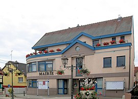
 The town hall in Achenheim The town hall in Achenheim | |
 Coat of arms Coat of arms | |
| Location of Achenheim | |
  | |
| Coordinates: 48°34′55″N 7°37′40″E / 48.5819°N 7.6278°E / 48.5819; 7.6278 | |
| Country | France |
| Region | Grand Est |
| Department | Bas-Rhin |
| Arrondissement | Strasbourg |
| Canton | Lingolsheim |
| Intercommunality | Eurométropole de Strasbourg |
| Government | |
| • Mayor (2020–2026) | Valentin Rabot |
| Area | 6.03 km (2.33 sq mi) |
| Population | 2,570 |
| • Density | 430/km (1,100/sq mi) |
| Time zone | UTC+01:00 (CET) |
| • Summer (DST) | UTC+02:00 (CEST) |
| INSEE/Postal code | 67001 /67204 |
| Elevation | 143–191 m (469–627 ft) (avg. 167 m or 548 ft) |
| French Land Register data, which excludes lakes, ponds, glaciers > 1 km (0.386 sq mi or 247 acres) and river estuaries. | |
Achenheim (French pronunciation: [axənaim] ; Alsatian: Àchene) is a commune in the Bas-Rhin department and Grand Est region of north-eastern France.
The village, which is in the arrondissement of Strasbourg and the canton of Lingolsheim lies close to the Canal de la Bruche and to the departmental road connecting Soultz-les-Bains to Strasbourg.
History
The oldest traces of human habitation in Alsace – tools used by Homo erectus in the Paleolithic era some 700,000 years ago – have been found in loess deposits at Achenheim.
In 1264 the village was burnt down by forces from Strasbourg during the war between the city and its bishop, Walter de Geroldseck.
Waterways
Administration
| Period | Name | Party | Remarks | |
|---|---|---|---|---|
| 2020 | incumbent | Valentin Rabot | ||
| 2012 | 2020 | Raymond Leipp | LR | Retired; acting mayor from 16.01.2012; re-elected in 2014 |
| 2008 | 2011 | Jean-Jacques Fritz | MoDem then NC | European Parliament director in Strasbourg, Regional Councillor |
| 1995 | 2008 | Roger Viola | DVD | CEO of a family firm supplying building materials; re-elected in 2001 |
Population
| Year | Pop. | ±% p.a. |
|---|---|---|
| 1968 | 1,207 | — |
| 1975 | 1,535 | +3.49% |
| 1982 | 1,717 | +1.61% |
| 1990 | 2,072 | +2.38% |
| 1999 | 2,183 | +0.58% |
| 2007 | 2,230 | +0.27% |
| 2012 | 2,043 | −1.74% |
| 2017 | 2,123 | +0.77% |
| Source: INSEE | ||
See also
References
- "Répertoire national des élus: les maires" (in French). data.gouv.fr, Plateforme ouverte des données publiques françaises. 13 September 2022.
- "Populations de référence 2022" (in French). The National Institute of Statistics and Economic Studies. 19 December 2024.
- INSEE commune file
- Population en historique depuis 1968, INSEE
This Bas-Rhin geographical article is a stub. You can help Misplaced Pages by expanding it. |