You can help expand this article with text translated from the corresponding article in French. (December 2008) Click for important translation instructions.
|
| Fegersheim Fajersche | |
|---|---|
| Commune | |
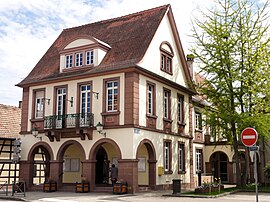
 The town hall in Fegersheim The town hall in Fegersheim | |
 Coat of arms Coat of arms | |
| Location of Fegersheim | |
  | |
| Coordinates: 48°29′29″N 7°40′52″E / 48.4914°N 7.6811°E / 48.4914; 7.6811 | |
| Country | France |
| Region | Grand Est |
| Department | Bas-Rhin |
| Arrondissement | Strasbourg |
| Canton | Lingolsheim |
| Intercommunality | Strasbourg Eurométropole |
| Government | |
| • Mayor (2020–2026) | Thierry Schaal |
| Area | 6.25 km (2.41 sq mi) |
| Population | 5,769 |
| • Density | 920/km (2,400/sq mi) |
| Time zone | UTC+01:00 (CET) |
| • Summer (DST) | UTC+02:00 (CEST) |
| INSEE/Postal code | 67137 /67640 |
| Elevation | 142–149 m (466–489 ft) |
| French Land Register data, which excludes lakes, ponds, glaciers > 1 km (0.386 sq mi or 247 acres) and river estuaries. | |
Fegersheim (French pronunciation: [fegəʁsajm] ) is a commune in the Bas-Rhin department in Grand Est in north-eastern France.
Geography and Economics
Fegersheim is located 12 kilometres (7 mi) to the south of Strasbourg, between the Rivers Andlau, Scheer and Ill.
Between 1962 and 1999 the registered population increased from 2153 to 4533, reflecting economic growth in the Strasbourg area.
History
The discovery of tombs from the third century BC indicates that the site was occupied during the Celtic period.
The little town acquired its urban status in the eleventh century. At that time the Benedictine monastery of nearby Eschau owned a substantial property in Fegersheim. In the following centuries until 1789 Fegersheim and its conjoined settlement of Ohnheim would be held as an episcopal fiefdom, successively, by Ochsenstein, Hanau-Lichtenberg and Rathsamhausen.
Fegersheim enjoyed a few days of prominence in 1680 when the court of Louis XIV, accompanied by Bishop Bossuet (tutor to the Dauphin) and the king's mistress stayed here while awaiting the arrival of the Grand Dauphins's new bride. Five days of public celebrations ensued.
For centuries Fegersheim survived on a traditional agrarian economy, but industry appeared in 1933 in the form of the Cajofé toy factory. In 1962 the local council designated one of France's first formal industrial zones here in order to encourage the provision of local employment. The industrial zone benefits from excellent road connections and the proximity of Strasbourg: its story has been one of successful development, already for nearly half a century.
Population
| Year | Pop. | ±% p.a. |
|---|---|---|
| 1968 | 2,350 | — |
| 1975 | 2,900 | +3.05% |
| 1982 | 3,646 | +3.32% |
| 1990 | 3,953 | +1.02% |
| 1999 | 4,533 | +1.53% |
| 2007 | 5,173 | +1.66% |
| 2012 | 5,443 | +1.02% |
| 2017 | 5,737 | +1.06% |
| Source: INSEE | ||
See also
References
- "Répertoire national des élus: les maires" (in French). data.gouv.fr, Plateforme ouverte des données publiques françaises. 13 September 2022.
- "Populations de référence 2022" (in French). The National Institute of Statistics and Economic Studies. 19 December 2024.
- INSEE commune file
- Population en historique depuis 1968, INSEE
This Bas-Rhin geographical article is a stub. You can help Misplaced Pages by expanding it. |