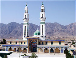
City in Fars, Iran
| Alamarvdasht Persian: علامرودشت | |
|---|---|
| City | |
 Imam Hasan Religious and Cultural Complex in Alamarvdasht Imam Hasan Religious and Cultural Complex in Alamarvdasht | |
 | |
| Coordinates: 27°37′26″N 53°00′04″E / 27.62389°N 53.00111°E / 27.62389; 53.00111 | |
| Country | Iran |
| Province | Fars |
| County | Lamerd |
| District | Alamarvdasht |
| Elevation | 470 m (1,540 ft) |
| Population | |
| • Total | 4,068 |
| Time zone | UTC+3:30 (IRST) |
| Area code | 071-5278 |
| Website | www |
Alamarvdasht (Persian: علامرودشت) is a city in, and the capital of, Alamarvdasht District of Lamerd County, Fars province, Iran. It also serves as the administrative center for Alamarvdasht Rural District.
Demographics
Population
At the time of the 2006 National Census, the city's population was 3,502 in 811 households. The following census in 2011 counted 4,095 people in 1,008 households. The 2016 census measured the population of the city as 4,068 people in 1,139 households.
Geography
Climate
Alamarvdasht features a hot semi arid climate, (Köppen climate classification: BSh). Due to annual precipitation is in the range of 50%–100% of the threshold, the classification is BSh (Hot semi-arid climate).
| Climate data for Alamarvdasht, Altitude: 457 M | |||||||||||||
|---|---|---|---|---|---|---|---|---|---|---|---|---|---|
| Month | Jan | Feb | Mar | Apr | May | Jun | Jul | Aug | Sep | Oct | Nov | Dec | Year |
| Record high °C (°F) | 30.4 (86.7) |
31 (88) |
36.2 (97.2) |
40 (104) |
47.7 (117.9) |
49.6 (121.3) |
49 (120) |
48.6 (119.5) |
47.4 (117.3) |
43.4 (110.1) |
39.4 (102.9) |
32.8 (91.0) |
49.6 (121.3) |
| Mean daily maximum °C (°F) | 21 (70) |
22 (72) |
26 (79) |
31.8 (89.2) |
38.9 (102.0) |
44 (111) |
45 (113) |
44 (111) |
41.9 (107.4) |
38 (100) |
31 (88) |
24 (75) |
34.0 (93.1) |
| Mean daily minimum °C (°F) | 7 (45) |
8.1 (46.6) |
11 (52) |
14.09 (57.36) |
20.38 (68.68) |
23 (73) |
26 (79) |
26 (79) |
23.3 (73.9) |
19 (66) |
14 (57) |
9 (48) |
16.74 (62.13) |
| Record low °C (°F) | −2.8 (27.0) |
−1 (30) |
3 (37) |
6.4 (43.5) |
10.4 (50.7) |
16.6 (61.9) |
19 (66) |
22 (72) |
17.2 (63.0) |
12 (54) |
4.6 (40.3) |
−1 (30) |
−2.8 (27.0) |
| Average precipitation mm (inches) | 67.3 (2.65) |
48.61 (1.91) |
32.34 (1.27) |
17.96 (0.71) |
2.15 (0.08) |
1.37 (0.05) |
2.02 (0.08) |
9.12 (0.36) |
5.70 (0.22) |
0.70 (0.03) |
5.42 (0.21) |
70.61 (2.78) |
263.3 (10.35) |
| Average rainy days | 5 | 5 | 5 | 4 | 1 | 0 | 0 | 1 | 1 | 1 | 2 | 5 | 30 |
| Average snowy days | 0 | 0 | 0 | 0 | 0 | 0 | 0 | 0 | 0 | 0 | 0 | 0 | 0 |
| Average relative humidity (%) | 62 | 60 | 51 | 42 | 28 | 22 | 29 | 36 | 38 | 38 | 45 | 57 | 42 |
| Mean monthly sunshine hours | 233.2 | 226.1 | 243.4 | 242.7 | 305.1 | 349.5 | 323.0 | 305.8 | 310.9 | 295.0 | 269.2 | 242.0 | 3,345.9 |
| Source: | |||||||||||||
See also
![]() Media related to Alamarvdasht at Wikimedia Commons
Media related to Alamarvdasht at Wikimedia Commons
Notes
- Formerly the village of Chah Ayni (چاه عینی)
References
- OpenStreetMap contributors (6 October 2024). "Alamarvdasht, Lamerd County" (Map). OpenStreetMap (in Persian). Retrieved 6 October 2024.
- ^ Census of the Islamic Republic of Iran, 1395 (2016): Fars Province. amar.org.ir (Report) (in Persian). The Statistical Center of Iran. Archived from the original (Excel) on 6 April 2022. Retrieved 19 December 2022.
- Alamarvdasht can be found at GEOnet Names Server, at this link, by opening the Advanced Search box, entering "-3052261" in the "Unique Feature Id" form, and clicking on "Search Database".
- Habibi, Hassan (c. 2024) . The transformation of Chah Ayni village, the center of Alamarvdasht District of Lamerd County, into Alamarvdasht city. lamtakam.com (Report) (in Persian). Ministry of the Interior, Political-Defense Commission of the Government Council. Archived from the original on 20 April 2024. Retrieved 20 April 2024 – via Lam ta Kam.
- Habibi, Hassan (c. 2023) . Creation and establishment of rural districts and districts in Fars province. lamtakam.com (Report) (in Persian). Ministry of the Interior, Council of Ministers. Proposal 17549.1.4.42; Notification 10908/T47K. Archived from the original on 9 December 2023. Retrieved 9 December 2023 – via Lam ta Kam.
- Mousavi, Mirhossein (c. 2023) . Creation and formation of 22 rural districts including villages, farms and places in Lar County under Fars province. lamtakam.com (Report) (in Persian). Ministry of the Interior, Council of Ministers. Proposal 17013. Archived from the original on 8 December 2023. Retrieved 8 December 2023 – via Lam ta Kam.
- Census of the Islamic Republic of Iran, 1385 (2006): Fars Province. amar.org.ir (Report) (in Persian). The Statistical Center of Iran. Archived from the original (Excel) on 20 September 2011. Retrieved 25 September 2022.
- Census of the Islamic Republic of Iran, 1390 (2011): Fars Province. irandataportal.syr.edu (Report) (in Persian). The Statistical Center of Iran. Archived from the original (Excel) on 16 January 2023. Retrieved 19 December 2022 – via Iran Data Portal, Syracuse University.
- I.R OF IRAN METEOROLOGICAL ORGANIZATION ( IN PERSIAN ). 1993-2011
| Capital | |||||||||||||||||||||||||||||||||||||||||
|---|---|---|---|---|---|---|---|---|---|---|---|---|---|---|---|---|---|---|---|---|---|---|---|---|---|---|---|---|---|---|---|---|---|---|---|---|---|---|---|---|---|
| Districts |
| ||||||||||||||||||||||||||||||||||||||||
This Lamerd County location article is a stub. You can help Misplaced Pages by expanding it. |
