County in Fars, Iran
| Kharameh County Persian: شهرستان خرامه | |
|---|---|
| County | |
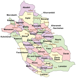
 Location of Kharameh County in Fars province (top right, pink) Location of Kharameh County in Fars province (top right, pink) | |
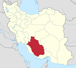
 Location of Fars province in Iran Location of Fars province in Iran | |
| Coordinates: 29°31′N 53°17′E / 29.517°N 53.283°E / 29.517; 53.283 | |
| Country | |
| Province | Fars |
| Capital | Kharameh |
| Districts | Central, Korbal |
| Population | |
| • Total | 54,864 |
| Time zone | UTC+3:30 (IRST) |
Kharameh County (Persian: شهرستان خرامه) is in Fars province, Iran. Its capital is the city of Kharameh.
History
After the 2006 National Census, Korbal District was separated from Shiraz County in the establishment of Kharameh County, which was divided into two districts and five rural districts, with Kharameh as its capital and only city at the time.
After the 2011 census, the village of Soltanabad rose to the status of a city as Soltan Shahr. After the 2016 census, the villages of Kheyrabad-e Tulalli and Moezzabad-e Jaberi were elevated to city status.
Demographics
Population
At the time of the 2011 census, the county's population was 61,580 people in 17,076 households. The 2016 census measured the population of the county as 54,864 in 16,874 households.
Administrative divisions
Kharameh County's population history and administrative structure over two consecutive censuses are shown in the following table.
| Administrative Divisions | 2011 | 2016 |
|---|---|---|
| Central District | 44,527 | 41,110 |
| Kafdehak RD | 8,383 | 7,390 |
| Kheyrabad RD | 6,514 | 6,616 |
| Moezzabad RD | 8,710 | 8,627 |
| Kharameh (city) | 20,920 | 18,477 |
| Kheyrabad-e Tulalli (city) | ||
| Moezzabad-e Jaberi (city) | ||
| Korbal District | 17,053 | 13,754 |
| Dehqanan RD | 8,736 | 4,803 |
| Sofla RD | 8,317 | 7,023 |
| Soltan Shahr (city) | 1,928 | |
| Total | 61,580 | 54,864 |
| RD = Rural District | ||
See also
![]() Media related to Kherameh County at Wikimedia Commons
Media related to Kherameh County at Wikimedia Commons
Notes
- Formerly Korbal Rural District
- ^ Became a city after the 2016 census
- Formerly Soltanabad
References
- OpenStreetMap contributors (5 October 2024). "Kharameh County" (Map). OpenStreetMap (in Persian). Retrieved 5 October 2024.
- ^ Census of the Islamic Republic of Iran, 1395 (2016): Fars Province. amar.org.ir (Report) (in Persian). The Statistical Center of Iran. Archived from the original (Excel) on 6 April 2022. Retrieved 19 December 2022.
- ^ Rahimi, Mohammad Reza (c. 2023) . Letter of approval regarding the national divisions in Fars province. qavanin.ir (Report) (in Persian). Ministry of the Interior, Cabinet of Ministers. Proposal 1/4/42/65970. Archived from the original on 23 September 2023. Retrieved 23 September 2023 – via Laws and Regulations Portal of the Islamic Republic of Iran.
- ^ Rahimi, Mohammad Reza (c. 2023) . Approval letter regarding country divisions in Fars province regarding the villages of Mazayjan, Baba Monir, Soltanabad, and Madar-e Soleyman. lamtakam.com (Report) (in Persian). Ministry of the Interior, Council of Ministers. Proposals 42/1/92501, 4/1/42/96946, 118058/4/1/42, and 4/1/42/136792; Notification 202890/T47288K. Archived from the original on 9 December 2023. Retrieved 9 December 2023 – via Lam ta Kam.
- ^ Jahangiri, Ishaq (2 October 2019) . Approval letter regarding national divisions in Kharameh County in Fars province. rc.majlis.ir (Report) (in Persian). Ministry of the Interior, Council of Ministers. Proposal 226667; Notification 48641/T56366H. Archived from the original on 23 September 2020. Retrieved 5 October 2024 – via Islamic Parliament Research Center of the Islamic Republic of Iran.
- ^ Census of the Islamic Republic of Iran, 1390 (2011): Fars Province. irandataportal.syr.edu (Report) (in Persian). The Statistical Center of Iran. Archived from the original (Excel) on 16 January 2023. Retrieved 19 December 2022 – via Iran Data Portal, Syracuse University.
