Commune in Hauts-de-France, France
| Anor | |
|---|---|
| Commune | |
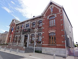
 The town hall in Anor The town hall in Anor | |
 Coat of arms Coat of arms | |
| Location of Anor | |
  | |
| Coordinates: 49°59′24″N 4°05′57″E / 49.99°N 4.0992°E / 49.99; 4.0992 | |
| Country | France |
| Region | Hauts-de-France |
| Department | Nord |
| Arrondissement | Avesnes-sur-Helpe |
| Canton | Fourmies |
| Intercommunality | Sud Avesnois |
| Government | |
| • Mayor (2020–2026) | Jean-Luc Pérat |
| Area | 22.24 km (8.59 sq mi) |
| Population | 3,152 |
| • Density | 140/km (370/sq mi) |
| Time zone | UTC+01:00 (CET) |
| • Summer (DST) | UTC+02:00 (CEST) |
| INSEE/Postal code | 59012 /59186 |
| Elevation | 200–271 m (656–889 ft) (avg. 238 m or 781 ft) |
| French Land Register data, which excludes lakes, ponds, glaciers > 1 km (0.386 sq mi or 247 acres) and river estuaries. | |
Anor (French pronunciation: [anɔʁ]) is a commune in the Nord department in northern France. It lies about forty kilometres (twenty-five miles) south-south-east of Maubeuge.
Population
|
| ||||||||||||||||||||||||||||||||||||||||||||||||||||||
| Source: EHESS and INSEE (1968-2017) | |||||||||||||||||||||||||||||||||||||||||||||||||||||||
Twin towns – sister cities
See also: List of twin towns and sister cities in FranceAnor is twinned with:
Heraldry
 |
The arms of Anor are blazoned : Vert billetty, a lion Or.
|
See also
References
- "Répertoire national des élus: les maires". data.gouv.fr, Plateforme ouverte des données publiques françaises (in French). 2 December 2020.
- "Populations de référence 2022" (in French). The National Institute of Statistics and Economic Studies. 19 December 2024.
- INSEE commune file
- Des villages de Cassini aux communes d'aujourd'hui: Commune data sheet Anor, EHESS (in French).
- Population en historique depuis 1968, INSEE
- "Comité de jumelage "Anor-Europe"". anor.fr (in French). Anor. Retrieved 23 April 2021.
This Nord geographical article is a stub. You can help Misplaced Pages by expanding it. |