Commune in Hauts-de-France, France
| Warlaing | |
|---|---|
| Commune | |
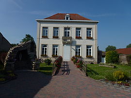
 The town hall The town hall | |
 Coat of arms Coat of arms | |
| Location of Warlaing | |
  | |
| Coordinates: 50°24′40″N 3°19′34″E / 50.4111°N 3.3261°E / 50.4111; 3.3261 | |
| Country | France |
| Region | Hauts-de-France |
| Department | Nord |
| Arrondissement | Douai |
| Canton | Sin-le-Noble |
| Intercommunality | Cœur d'Ostrevent |
| Government | |
| • Mayor (2020–2026) | Patrice Bricout |
| Area | 3.89 km (1.50 sq mi) |
| Population | 599 |
| • Density | 150/km (400/sq mi) |
| Time zone | UTC+01:00 (CET) |
| • Summer (DST) | UTC+02:00 (CEST) |
| INSEE/Postal code | 59642 /59870 |
| Elevation | 16–19 m (52–62 ft) (avg. 17 m or 56 ft) |
| French Land Register data, which excludes lakes, ponds, glaciers > 1 km (0.386 sq mi or 247 acres) and river estuaries. | |
Warlaing (French pronunciation: [waʁlɛ̃]) is a commune in the Nord department in northern France.
Heraldry
 |
The arms of Warlaing are blazoned : Or, a cross engrailed gules. (Artres, Bettrechies, Cerfontaine, Denain, Eth, Lesquin, Obies, Quérénaing, Semousies, Wambrechies and Warlaing use the same arms.)
|
Population
| Year | Pop. | ±% p.a. |
|---|---|---|
| 1968 | 359 | — |
| 1975 | 352 | −0.28% |
| 1982 | 340 | −0.49% |
| 1990 | 381 | +1.43% |
| 1999 | 461 | +2.14% |
| 2007 | 562 | +2.51% |
| 2012 | 542 | −0.72% |
| 2017 | 579 | +1.33% |
| Source: INSEE | ||
Sites and monuments
- Church of our Lady of the Assumption, built around 1852 by Lille architect Charles Leroy, who was the designer of many religious buildings in northern France, including the Notre-Dame de la Treille cathedral.
- The Château de Warlaing, now in ruins, was destroyed by the armies of Louis XIV.
- The Scarpe, its lock and bridge.
-
The road into Warlaing
-
The Church of Our Lady of the Assumption
-
The grotto of Lourdes
-
The lock of the Scarpe
-
The bascule bridge on the Scarpe
See also
References
- "Répertoire national des élus: les maires". data.gouv.fr, Plateforme ouverte des données publiques françaises (in French). 2 December 2020.
- "Populations de référence 2022" (in French). The National Institute of Statistics and Economic Studies. 19 December 2024.
- INSEE commune file
- Population en historique depuis 1968, INSEE
This Nord geographical article is a stub. You can help Misplaced Pages by expanding it. |