Map all coordinates using OpenStreetMap
Download coordinates as:
Suburb of Toowoomba Region, Queensland, Australia| Ascot Queensland | |||||||||||||||
|---|---|---|---|---|---|---|---|---|---|---|---|---|---|---|---|
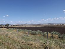
 Farm building at Ascot, 2014 Farm building at Ascot, 2014 | |||||||||||||||
 | |||||||||||||||
| Coordinates | 27°48′55″S 152°00′04″E / 27.8152°S 152.0011°E / -27.8152; 152.0011 (Ascot (centre of locality)) | ||||||||||||||
| Population | 106 (2021 census) | ||||||||||||||
| • Density | 3.202/km (8.29/sq mi) | ||||||||||||||
| Postcode(s) | 4359 | ||||||||||||||
| Area | 33.1 km (12.8 sq mi) | ||||||||||||||
| Time zone | AEST (UTC+10:00) | ||||||||||||||
| Location | |||||||||||||||
| LGA(s) | Toowoomba Region | ||||||||||||||
| State electorate(s) | Condamine | ||||||||||||||
| Federal division(s) | Groom | ||||||||||||||
| |||||||||||||||
Ascot is a rural locality in the Toowoomba Region, Queensland, Australia. In the 2021 census, Ascot had a population of 106 people.
Geography

Ascot is on the Darling Downs. Its southern boundary follows Kings Creek, a tributary of the Condamine River. The area is heavily developed for agriculture except for elevated areas in the east.
Mount Sibley is a neighbourhood in the north-west of the locality (27°50′00″S 151°58′00″E / 27.8333°S 151.9666°E / -27.8333; 151.9666 (Mount Sibley)), presumably taking its name from the nearby mountain of the same name in neighbouring East Greenmount. The mountain was named after James Sibley, a pastoralist and publican, who leased the Clifton pastoral run in the early 1840s.
History
Mount Sibley Provisional School opened in 1907. On 1 January 1909 it became Mount Sibley State School. It closed circa 1952. The school was located at 565 Mount Silbley Road (27°49′33″S 151°57′48″E / 27.8259°S 151.9634°E / -27.8259; 151.9634 (Mount Sibley State School (former))).
Demographics
In the 2016 census, Ascot had a population of 31 people.
In the 2021 census, Ascot had a population of 106 people.
Education
There are no schools in Ascot. The nearest primary school is Pilton State School in neighbouring Pilton to the south-east, Emu Creek State School in neighbouring East Greenmount to the north-west and Nobby State School in neighbouring Nobby to the south-west. The nearest secondary school is Clifton State High School in Clifton to the south-west.
References
- ^ Australian Bureau of Statistics (28 June 2022). "Ascot (SAL)". 2021 Census QuickStats. Retrieved 28 February 2023.

- "Ascot – locality in Toowoomba Region (entry 47884)". Queensland Place Names. Queensland Government. Retrieved 19 September 2020.
- ^ "Queensland Globe". State of Queensland. Retrieved 22 January 2021.
- "Mount Sibley – locality unbounded in Toowoomba Regional (entry 23147)". Queensland Place Names. Queensland Government. Retrieved 19 September 2020.
- "Mount Sibley – mountain in the Toowoomba Region (entry 30800)". Queensland Place Names. Queensland Government. Retrieved 17 April 2022.
- Queensland Family History Society (2010), Queensland schools past and present (Version 1.01 ed.), Queensland Family History Society, ISBN 978-1-921171-26-0
- "Parish of Haldon" (Map). Queensland Government. 1943. Archived from the original on 22 January 2021. Retrieved 22 January 2021.
- Australian Bureau of Statistics (27 June 2017). "Ascot (SSC)". 2016 Census QuickStats. Retrieved 20 October 2018.

External links
![]() Media related to Ascot, Toowomba Region at Wikimedia Commons
Media related to Ascot, Toowomba Region at Wikimedia Commons