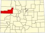
| Atchee, Colorado | |
|---|---|
| ghost town | |
  | |
| Coordinates: 39°33′47″N 108°54′46″W / 39.5630°N 108.9129°W / 39.5630; -108.9129 | |
| Country | |
| State | |
| County | Garfield |
| Elevation | 6,418 ft (1,956 m) |
| Time zone | UTC−07:00 (MST) |
| • Summer (DST) | UTC−06:00 (MDT) |
| GNIS ID | 172111 |
Atchee is a ghost town in Garfield County, Colorado. It was originally a railroad village/company town owned by the Gilsonite Company that served as a shopping town on the narrow-gauge Uintah Railway. The railroad served mines in nearby Utah. At a point in time, the railroad was dismantled which led to a sharp population decline. By 1938, there were only 27 voters in the town and by 1940 only two voters remained.
History
The Atchee, Colorado, post office operated from September 26, 1905, until April 30, 1940. The town was a company town and thus almost everyone in the town worked for the Gilsonite Company. The houses all had running water and steam heat as well as being served by electricity. Atchee was never an incorporated town.
Rail line
The rail line was the lifeblood of the town, with the town's population sharply declining and eventually falling into ghost town status after the demolition of the rail line. The line itself ran from Mack, Colorado, to Watson, Utah, with a spur to the Rainbow Mine in Utah from Watson. During the summer, there were special trains run for students of the Colorado School of Mines.
See also
- Bibliography of Colorado
- Geography of Colorado
- History of Colorado
- Index of Colorado-related articles
- List of Colorado-related lists
- Outline of Colorado
References
- "Colorado Counties". Colorado Department of Local Affairs. Retrieved December 30, 2024.
- ^ "Atchee, Colorado". Geographic Names Information System. United States Geological Survey, United States Department of the Interior. Retrieved December 30, 2024.
- ^ Luton, Ruby (26 April 1978). "Oral history with 83 year old female, Colorado (Transcript)" (Interview). Interviewed by Kyle, Evelyn; Nelson, Justina. Center for Applied Linguistics Collection. Retrieved 11 December 2021.
- ^ "Only 2 Voters Stay in Once Thriving Town". Warsaw Union. Reub. Williams & Sons. United Press. 4 December 1940. Retrieved 11 December 2021.
- Bauer, William H.; Ozment, James L.; Willard, John H. (1990). Colorado Post Offices 1859–1989. Golden, Colorado: Colorado Railroad Historical Foundation. ISBN 0-918654-42-4.
External links
| Municipalities and communities of Garfield County, Colorado, United States | ||
|---|---|---|
| County seat: Glenwood Springs | ||
| Cities |  | |
| Towns | ||
| CDPs | ||
| Unincorporated communities | ||
| Ghost town | ||
This Colorado-related article is a stub. You can help Misplaced Pages by expanding it. |