| Bačko Novo Selo Бачко Ново Село (Serbian) | |
|---|---|
 The Saint Ana Catholic Church The Saint Ana Catholic Church | |
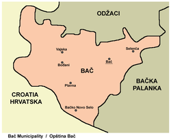
 Map of the Bač municipality showing the location of Bačko Novo Selo Map of the Bač municipality showing the location of Bačko Novo Selo | |
   | |
| Coordinates: 45°18′N 19°08′E / 45.300°N 19.133°E / 45.300; 19.133 | |
| Country | |
| Province | |
| Region | Bačka (Podunavlje) |
| District | South Bačka |
| Municipality | |
| Population | |
| • Total | 1,228 |
| Time zone | UTC+1 (CET) |
| • Summer (DST) | UTC+2 (CEST) |
Bačko Novo Selo (Serbian Cyrillic: Бачко Ново Село listen) is a village in Serbia. It is situated in the Bač municipality, South Bačka District, Vojvodina province. The village has a Serb ethnic majority and a Bosniak minority. Its population numbering 1,228 people (2002 census). The village was formally known as Batsch Neudorf prior to World War Two. The etymology of the village comes from Slavic languages meaning new village, Novo Selo and Bačko from the region it’s in Bačka.
History
Bačko Novo Selo was historically populated by Danube Swabians. Following the end of the Second World War, the Yugoslav Communist authorities displaced the German population of the village and resettled families from Bosnia. The Yugoslav Communist authorities aimed to develop Bačko Novo Selo into a Muslim colony of Vojvodina, however, by the spring of 1947, only an estimated 138 out of an expected 320 Muslim families settled in Bačko Novo Selo.
Geography
Neighbouring places are Plavna and Mladenovo (both located in Bačka), as well as Sotin and Opatovac, which are situated across the Danube in the Croatian part of Syrmia.
Historical population
- 1961: 2,236
- 1971: 1,665
- 1981: 1,522
- 1991: 1,365
Famous residents
- Refik Memišević, wrestle champion, born in 1956 in Bačko Novo Selo
- Refik Kozić, footballer, born in 1950 in Bačko Novo Selo
See also
References
- Slobodan Ćurčić, Broj stanovnika Vojvodine, Novi Sad, 1996.
- Pencz, Rudolf (2009). For the Homeland The 31st Waffen-SS Volunteer Grenadier Division in World War II. Stackpole Books. ISBN 9781461751038.
- Attila Hoare, Marko (2014). The Bosnian Muslims in the Second World War. Oxford University Press. p. 340. ISBN 9780199365432.
- "Refik Memišević". Archived from the original on 2007-07-12. Retrieved 2007-05-15.
External links
| Cities, towns and villages in the South Bačka District | |
|---|---|
| Seat of the district: Novi Sad | |
| Novi Sad | |
| Petrovaradin | |
| Bač | |
| Bačka Palanka | |
| Bački Petrovac | |
| Bečej | |
| Beočin | |
| Srbobran | |
| Sremski Karlovci |
|
| Temerin | |
| Titel | |
| Vrbas | |
| Žabalj | |
| (*) bold are municipalities or cities, 1 - Novi Sad`s urban municipalities, which aren't fully formed | |
45°18′N 19°08′E / 45.300°N 19.133°E / 45.300; 19.133
This South Bačka District, Vojvodina location article is a stub. You can help Misplaced Pages by expanding it. |