| Susek Сусек (Serbian) | |
|---|---|
| Village (Selo) | |
 Church of the Holy Archangel Gabriel Church of the Holy Archangel Gabriel | |
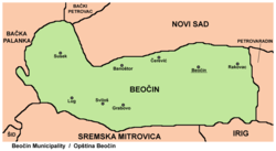
 Map of the Beočin municipality, showing the location of Susek Map of the Beočin municipality, showing the location of Susek | |
   | |
| Coordinates: 45°13′N 19°32′E / 45.217°N 19.533°E / 45.217; 19.533 | |
| Country | |
| Province | |
| Region | Syrmia (Podunavlje) |
| District | South Bačka |
| Municipality | Beočin |
| Population | |
| • Total | 998 |
| Time zone | UTC+1 (CET) |
| • Summer (DST) | UTC+2 (CEST) |
Susek (Serbian Cyrillic: Сусек) is a village in Serbia. It is situated in the Beočin municipality, in the Vojvodina province. Although, the village is geographically located in Syrmia, it is part of the South Bačka District. The village has a Serb ethnic majority and its population numbering 1,132 people (2002 census).
History
During the Axis occupation in World War II, 252 civilians were killed in Susek by fascists.
Historical population
- 1961: 1,502
- 1971: 1,440
- 1981: 1,217
- 1991: 1,137
- 2011: 998
See also
References
- Miloš Lukić, Putevima slobode - naselja opštine Beočin u ratu i revoluciji, Novi Sad, 1987.
- Slobodan Ćurčić, Broj stanovnika Vojvodine, Novi Sad, 1996.
External links
| Cities, towns and villages in the South Bačka District | |
|---|---|
| Seat of the district: Novi Sad | |
| Novi Sad | |
| Petrovaradin | |
| Bač | |
| Bačka Palanka | |
| Bački Petrovac | |
| Bečej | |
| Beočin | |
| Srbobran | |
| Sremski Karlovci |
|
| Temerin | |
| Titel | |
| Vrbas | |
| Žabalj | |
| (*) bold are municipalities or cities, 1 - Novi Sad`s urban municipalities, which aren't fully formed | |
45°13′N 19°32′E / 45.217°N 19.533°E / 45.217; 19.533
This South Bačka District, Vojvodina location article is a stub. You can help Misplaced Pages by expanding it. |