| Nickname: Asparagus Island | |
|---|---|
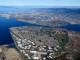
 Aerial view of Bay Farm Island in October 2020 Aerial view of Bay Farm Island in October 2020 | |
   | |
| Geography | |
| Location | Northern California |
| Coordinates | 37°44′13″N 122°14′06″W / 37.737°N 122.235°W / 37.737; -122.235 |
| Adjacent to | San Leandro Bay |
| Total islands | 1 |
| Administration | |
| United States | |
| State | |
| County | Alameda |
| City | Alameda |
Bay Farm Island is a district of the city of Alameda, California, though it is separated from the rest of the city on Alameda Island by an estuary of San Leandro Bay. Its ZIP code is 94502. The location was originally an island in San Francisco Bay, but due to land reclamation it has become a peninsula and is now connected to the mainland of Oakland and Oakland International Airport. Marshes and other areas of the island were also reclaimed.
Prior to 20th century development, Bay Farm Island was farmland with asparagus being the principal crop, thus it was also formerly known as Asparagus Island. In addition, the area was the site of large oyster beds which regularly supplied restaurants in nearby San Francisco.
Bay Farm is home to the 36-hole Chuck Corica Golf Complex, office and retail complexes, and several housing developments. There is a chain of lagoons as well as several community parks including Shoreline Park. Four elementary schools serve the island: Bay Farm Elementary, Chinese Christian School, Coastline Christian School, and Amelia Earhart Elementary. Bay Farm was the home of the headquarters of the Oakland Raiders when the team was in Oakland from 1995 until 2020.
A greenbelt is also present which encompasses the perimeter of the peninsula.
Harbor Bay Isle
The largest development on Bay Farm is named "Harbor Bay Isle", generally bounded to the north and west portion of the island by Island Drive and Mecartney Road. Harbor Bay Isle is divided into seven villages; six villages cover twenty homeowner's associations in each of the residential subdivisions, and one village covers commercial interests, including the Harbor Bay business park. Harbor Bay Isle excludes the three southern townhome developments, Islandia, Casitas, and Garden Isle, as well as the single-family homes to the east of Island Drive. Much of the development is built on reclaimed land.

Southern Crossing
Main article: Southern Crossing (California)Bay Farm was proposed as a site for the eastern end of another bridge from San Francisco across San Francisco Bay. The so-called Southern Crossing was first conceptualized in the 1940s and canceled in 1958.
Schools
There are three elementary schools on Bay Farm Island: Bay Farm Elementary, Coastline Christian Schools (formerly Chinese Christian Schools), and Amelia Earhart Elementary. The latter is named for aviator Amelia Earhart, who started many of her flights from the nearby Oakland Airport.
Notable residents
- Chris Isaak, recording artist
- David Segui, former MLB first baseman
- Jim Otto, former center for Oakland Raiders
- Stan Bunger, radio broadcast journalist
Public transit
AC Transit provides local bus service in addition to express commuter "Transbay" service to the Transbay Terminal in Downtown San Francisco. In the weekday mornings and afternoons there are student only bus rides from neighborhoods on Bay Farm Island to various local schools.
The free Harbor Bay Business Park Shuttle connects the Harbor Bay Ferry Terminal with the Harbor Bay Business Park and Oakland Coliseum station.
In addition, the Harbor Bay Ferry provides commuter (rush hour) service to the San Francisco Ferry Building.
See also
References
- "Sector Four". City of Alameda. Archived from the original on 2014-10-16. Retrieved 2014-10-10.
- ^ "Asparagus Growing in Alameda". Pacific Rural Press. Vol. 54, no. 24. 11 December 1897. Retrieved 3 May 2017.
- Minor, Woody (November 2005). "Alameda on the Half Shell: Farming Oysters in the Island City". Alameda. Retrieved 3 May 2017.
- "Management Services". Harbor Bay Isle. Retrieved 3 May 2017.
- "Another Bay Bridge Plan Falls By Wayside With New Decision". Madera Tribune. U.P. 7 April 1958. Retrieved 3 May 2017.
- "AC Transit | Alameda-Contra Costa Transit District". Archived from the original on 2016-11-06. Retrieved 2009-12-22. AC Transit website
- Harbor Bay Business Park Shuttle Schedule
- "Alameda Harbor Bay Ferry | Discover San Francisco Bay Ferry". Archived from the original on 2016-09-07. Retrieved 2009-12-22. Harbor Bay Ferry website
External links
- Baker, David (28 March 2014). "Alameda in history: Bay Farm Island". The Alamedan. Archived from the original on April 19, 2014. Retrieved 3 May 2017.
- Lano, Michael (29 August 2014). "Alameda in history: The First Families of Bay Farm Island". The Alamedan. Archived from the original on September 1, 2014. Retrieved 3 May 2017.
| Alameda, California | |
|---|---|
| Landmarks | |
| Economy | |
| Education | |
| History | |
| Infrastructure | |
| Locations | |
| East Bay | |
|---|---|
| Counties | |
| Major cities | |
| Cities and towns 25k-100k | |
| Cities and towns 10k-25k | |
| Cities and towns under 10k | |
| Regional organizations | |

