| Coyote Creek | |
|---|---|
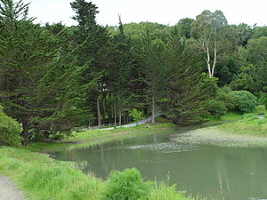
 Coyote Creek flowing through Tam Valley Coyote Creek flowing through Tam Valley | |
| Location | |
| Country | United States |
| State | California |
| Region | Marin County |
| Physical characteristics | |
| Source | |
| • location | Coyote Ridge |
| • coordinates | 37°52′06″N 122°32′52″W / 37.86833°N 122.54778°W / 37.86833; -122.54778 |
| • elevation | 700 ft (210 m) |
| Mouth | Richardson's Bay |
| • location | Tam Valley, California |
| • coordinates | 37°52′59″N 122°31′08″W / 37.88306°N 122.51889°W / 37.88306; -122.51889 |
| • elevation | 0 ft (0 m) |

Coyote Creek is a stream in the Richardson Bay watershed, draining Tamalpais-Homestead Valley, California (Tam Valley) eastward into Richardson Bay, Marin County, California, United States. The stream originates on Coyote Ridge and flows 2.5 miles (4.0 km) to the bay at the south end of Bothin Marsh. Coyote Creek is surrounded by a walking/biking path that stretches all the way until the creek reaches the bay (see photo on right, path located around the Creek).
History
The Richardson Bay watershed is located on the aboriginal lands of the Coast Miwok. The Coast Miwok Tribe came to California before the European Settlers. They significantly impacted and inhabited the areas of Marin County and Southern Sonoma County. Spanish colonization began in neighboring Sausalito, California, in 1775, when Juan de Ayala sailed the first ship (the San Carlos) into San Francisco Bay. These explorers named the area Saucelito (“little willows”) after the vegetation spotted from shipboard. When the Mission San Rafael Arcángel, established in 1817, was secularized by the Mexican government in 1834, the mission lands were granted to prominent Californios as ranchos. The Rancho Corte Madera del Presidio (literally, “place where wood is cut for the Presidio”) included a sawmill for processing redwood trees, cattle and horse ranches, a brickyard, and a stone quarry. Sausalito became an important ferry port, connecting Marin to San Francisco. The railroad brought supplies from the north to be shipped across San Francisco Bay.
Habitat and ecology
Historically, Coyote Creek hosted California golden beaver (Castor canadensis subauratus) whose beaver dams likely played a role in removing sediment and improving over-summering habitat for steelhead and salmon smolt.
Other than the beavers, there are many other wild animals that call Coyote Creek home. More specifically, Coyote Creek is located in a neighborhood surrounded by a neighborhood in Mill Valley, CA nicknamed “Bird Land.” Surrounding and in the creek, there are all different species of birds found- from Scrub Blue Jays to Egrets to ducks. These birds are seen around and swimming in the creek.
Habitat and ecology- Photo Library
As stated above, the wildlife seen at the creek is quite remarkable. Check out this to see photos of some of the bids that frequent Coyote Creek: https://docs.google.com/document/d/10oW9GlLx2S1xPlkUu-oFwo9VZqG1g_IkAIy24EoTD-s/edit?usp=sharing
Flood Zone #3- Coyote Creek
Coyote Creek is located under Flood Zone #3 which includes areas in Southern Marin that goes into Richardson Bay. In order to reduce flood risks, Marin County has implemented different flood control devices. One major thing for Coyote Creek that protects the residents in surrounding neighborhoods is the sump pump stations. If there is a flooding risk, these pumps can remove water from the creek/affected areas to others channels that aren’t experiencing over abundance of water.
See also
References
- ^ U.S. Geological Survey Geographic Names Information System: Coyote Creek
- Durham, David L. (1998). Durham's Place Names of California's San Francisco Bay Area: Includes Marin, San Francisco, San Mateo, Contra Costa, Alameda, Solano & Santa Clara counties. Word Dancer Press, Sanger, California. p. 620. ISBN 1-884995-14-4. Retrieved Jan 13, 2010.
- "Coast Miwok at Point Reyes". Point Reyes National Seashore. U.S. National Park Service. Retrieved 2024-10-23.
- Marin County Department of Public Works. "Richardson Bay Watershed". Archived from the original on October 31, 2010. Retrieved Jan 13, 2010.
- Skinner, John E. (1962). An Historical Review of the Fish and Wildlife Resources of the San Francisco Bay Area (The Mammalian Resources). California Department of Fish and Game, Water Projects Branch Report no. 1. Sacramento, California: California Department of Fish and Game. Retrieved 2010-11-13.
- "Flood Control Zones Special Districts - Flood Control Zones in Marin County (FCZ)". marincounty.gov. August 15, 2024.
External links
- U.S. Geological Survey Geographic Names Information System: Coyote Creek - Geographic Names Information System
- Richardson Bay Watershed Map
- Guide to San Francisco Bay Area Creeks
