| Castellbell i el Vilar | |
|---|---|
| Municipality | |
 | |
 Coat of arms Coat of arms | |
  | |
| Coordinates: 41°38′2″N 1°51′50″E / 41.63389°N 1.86389°E / 41.63389; 1.86389 | |
| Country | |
| Community | |
| Province | Barcelona |
| Comarca | Bages |
| Government | |
| • Mayor | Montserrat Badia Moreno (2015) |
| Area | |
| • Total | 28.5 km (11.0 sq mi) |
| Elevation | 178 m (584 ft) |
| Population | |
| • Total | 3,599 |
| • Density | 130/km (330/sq mi) |
| Demonym(s) | Castellvilanenc, castellvilanenca |
| Website | castellbellielvilar |
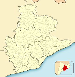
Castellbell i el Vilar (Catalan pronunciation: [kəsˌteʎˈbeʎ i əl βiˈla]) is a municipality in the comarca of the Bages in Catalonia, Spain. It is situated at the point where the Llobregat river crosses the Prelittoral Range. The railway station serves both the FGC line R5 between Barcelona and Manresa and the Renfe line between Barcelona and Zaragoza. The C-1411 road links the municipality with Martorell and Manresa.
Castellbell i el Vilar is known for its cotton industry, although agriculture is at least as important to the local economy. Castellbell castle (gothic, fourteenth century) was one of the two main points (along with Claramunt castle) controlling access to the lower Llobregat valley, and hence to Barcelona. The bridge over the Llobregat also dates from the fourteenth century.
Demography
| 1900 | 1930 | 1950 | 1970 | 1986 | 2007 |
|---|---|---|---|---|---|
| 2026 | 2952 | 3189 | 3527 | 3316 | 3479 |
References
- "Ajuntament de Castellbell i el Vilar". Generalitat of Catalonia. Retrieved 2015-11-13.
- "El municipi en xifres: Castellbell i el Vilar". Statistical Institute of Catalonia. Retrieved 2015-11-23.
- Municipal Register of Spain 2018. National Statistics Institute.
- Panareda Clopés, Josep Maria; Rios Calvet, Jaume; Rabella Vives, Josep Maria (1989). Guia de Catalunya, Barcelona: Caixa de Catalunya. ISBN 84-87135-01-3 (Spanish). ISBN 84-87135-02-1 (Catalan).
External links
| Llobregat–Anoia Line | |||||||||||||||||||||||||||||||||||||||||||||||||||||||||||||||||||||||||||||||||||||||||||||||||||||||||||||||||||||||||||||||||||||||||||||||||||||||||||||||||||||||||||||||||||||||||||||||||||||||||||||||||||||||||||||||||||||||||||||||||||||||||||||||||||||||||||||||||||||||||||||||||||||||||||||||||||||
|---|---|---|---|---|---|---|---|---|---|---|---|---|---|---|---|---|---|---|---|---|---|---|---|---|---|---|---|---|---|---|---|---|---|---|---|---|---|---|---|---|---|---|---|---|---|---|---|---|---|---|---|---|---|---|---|---|---|---|---|---|---|---|---|---|---|---|---|---|---|---|---|---|---|---|---|---|---|---|---|---|---|---|---|---|---|---|---|---|---|---|---|---|---|---|---|---|---|---|---|---|---|---|---|---|---|---|---|---|---|---|---|---|---|---|---|---|---|---|---|---|---|---|---|---|---|---|---|---|---|---|---|---|---|---|---|---|---|---|---|---|---|---|---|---|---|---|---|---|---|---|---|---|---|---|---|---|---|---|---|---|---|---|---|---|---|---|---|---|---|---|---|---|---|---|---|---|---|---|---|---|---|---|---|---|---|---|---|---|---|---|---|---|---|---|---|---|---|---|---|---|---|---|---|---|---|---|---|---|---|---|---|---|---|---|---|---|---|---|---|---|---|---|---|---|---|---|---|---|---|---|---|---|---|---|---|---|---|---|---|---|---|---|---|---|---|---|---|---|---|---|---|---|---|---|---|---|---|---|---|---|---|---|---|---|---|---|---|---|---|---|---|---|---|---|---|---|---|---|---|---|---|---|---|---|---|---|---|---|---|---|---|---|---|---|---|---|---|---|---|---|---|---|---|---|---|---|---|---|---|
| Legend | |||||||||||||||||||||||||||||||||||||||||||||||||||||||||||||||||||||||||||||||||||||||||||||||||||||||||||||||||||||||||||||||||||||||||||||||||||||||||||||||||||||||||||||||||||||||||||||||||||||||||||||||||||||||||||||||||||||||||||||||||||||||||||||||||||||||||||||||||||||||||||||||||||||||||||||||||||||
| |||||||||||||||||||||||||||||||||||||||||||||||||||||||||||||||||||||||||||||||||||||||||||||||||||||||||||||||||||||||||||||||||||||||||||||||||||||||||||||||||||||||||||||||||||||||||||||||||||||||||||||||||||||||||||||||||||||||||||||||||||||||||||||||||||||||||||||||||||||||||||||||||||||||||||||||||||||
- Official website (in Catalan)
- Government data pages (in Catalan)
| Places adjacent to Castellbell i el Vilar | ||||||||||||||||
|---|---|---|---|---|---|---|---|---|---|---|---|---|---|---|---|---|
| ||||||||||||||||
