| Clisham | |
|---|---|
| Scottish Gaelic: An Cliseam | |
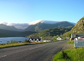
 View of the Clisham from Ardhasaig View of the Clisham from Ardhasaig | |
| Highest point | |
| Elevation | 799 m (2,621 ft) |
| Prominence | 799 m (2,621 ft) |
| Isolation | 82.62 km (271,100 ft) |
| Coordinates | 57°57′49.32″N 6°48′45″W / 57.9637000°N 6.81250°W / 57.9637000; -6.81250 |
| Dimensions | |
| Length | 4.9 km (3.0 mi) |
| Naming | |
| Native name | An Cliseam (Scottish Gaelic) |
| English translation | Rocky cliff |
| Pronunciation | Scottish Gaelic: [əŋ ˈkʰliʃəm] |
| Defining authority | Na h-Eileanan an Iar |
| Geography | |
| Location | Isle of Harris, Outer Hebrides |
| Countries | Scotland, United Kingdom |
| OS grid | NB154073 |
The Clisham (Scottish Gaelic: An Cliseam) is a mountain on North Harris, Lewis and Harris in the Outer Hebrides of Scotland. At 799 metres (2,621 ft), it is the highest mountain in the Outer Hebrides and the archipelago's only Corbett. Climbers often encounter light rain and boggy and muddy terrain.
There are a number of paths up to the Clisham's peak. The fastest way to the summit begins at the car park at the bridge along the A859 road between Stornoway and Tarbert and southeast of the mountain. When the visibility is clear, the view from the summit shows all of the Clisham horseshoe peaks: An t-Isean, Mulla bho Dheas, Mulla bho Thuath, and Mullach an Langa. From the southwest side of the peak, Coire Dubh Slabs is visible, and from the north is Aonaig Mhòr.
A more advanced hike traverses the Clisham horseshoe beginning at the northern part of the Abhainn Scaladail and moving upstream to the foot of the Mullach an Langa ridge. The distance of the Horseshoe is about 12.5 km. Another advanced path along the horseshoe starts at the northwest along the ridge made by the Mullach an Langa, Mulla-Fo-Thuath and Mulla-Fo-Dheas.
References
- ^ "Walks on Harris". Explore Scotland. n.d. Retrieved 13 February 2022.
- "An Cliseam". Guide to Scotland's Hills and Mountains. n.d. Retrieved 13 February 2022.
- "Isolation for Clisham". Peak Bagger. n.d. Retrieved 13 February 2022.
- ^ "Clisham". The Editors of the Gazetteer for Scotland. 2019. Retrieved 13 February 2022.
- ^ Smith, Andy (n.d.). "Outer Hebrides Walk: An Cliseam, Isle of Harris". Walking Britain. Retrieved 13 February 2022.
- Bailey, Dan. Great Mountain Days in Scotland: 50 Classic Hillwalking Challenges. p. 250.
- "An Cliseam [Clisham]". Hill Bagging. n.d. Retrieved 13 February 2022.
- ^ Laing, Katie (6 November 2019). "Explore the outdoors: View from the top of Clisham horseshoe on Lewis is worth the climb". The Press and Journal. Retrieved 13 February 2022.
- "An Cliseam". UK Climbing. n.d. Retrieved 13 February 2022.
- "Clisham (An Cliseam) horseshoe". WalkHighlands. n.d. Retrieved 13 February 2022.
- "Clisham Horseshoe". Visit Outer Hebrides. n.d. Retrieved 13 February 2022.
| Lewis and Harris | ||
|---|---|---|
| Inhabited islands | ||
| Other islands | ||
| Settlements |
| |
| Districts | ||
| Geographical features | ||
| Historical sites | ||
| Most prominent mountains of Britain and Ireland (the P600s) | ||
|---|---|---|
| Northern Highlands (20) |    | |
| Western Highlands (20) | ||
| Central and Eastern Highlands (13) | ||
| Southern Highlands (15) | ||
| Islands (13) | ||
| Scottish Lowlands, England and Wales (13) | ||
| Republic of Ireland, Northern Ireland (25) | ||
This article about a location in the Western Isles is a stub. You can help Misplaced Pages by expanding it. |