| Arroyo Conejo | |
|---|---|
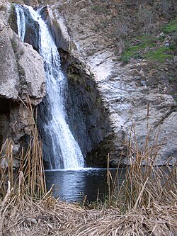
 Paradise Falls Paradise Falls | |
| Location | |
| Country | United States |
| County | Ventura |
| Physical characteristics | |
| Mouth | |
| • location | Discharges to the Pacific by Mugu Lagoon |
| Basin features | |
| River system | Calleguas Creek |
Arroyo Conejo (Spanish for “Rabbit Creek”) carries part of the longest creek in the Conejo Valley which sprawls past the cities of Thousand Oaks and Camarillo, and the communities of Newbury Park, Casa Conejo and Santa Rosa Valley. Arroyo Conejo is the primary drainage for the City of Thousand Oaks. Its watershed covers 57 square miles (150 km) of which 43 square miles (110 km) are in the Conejo Valley and 14 square miles (36 km) in the Santa Rosa Valley.
Historically, it was a seasonal-running creek but urban runoff from irrigation currently makes it perennial. Its north fork carved Wildwood Canyon out of bedrock over several millennia. The south fork originates in the Conejo Hills above Newbury Park. It also follows Thousand Oaks Boulevard, where it runs directly along and below the boulevard. In certain areas, the creek runs through concrete culverts and runs underneath the street. Past Newbury Park's Hill Canyon, the creek meets with Arroyo Santa Rosa in Santa Rosa Valley as it runs through the Pleasant Valley basin on its way across the Oxnard Plain to its estuary at Mugu Lagoon. Due to limited access, suggestions have been made to make its banks into public amenities similar to that of San Antonio River Walk, or, developing a public use trail following the creek, similar to the bike path of Arroyo Simi in Simi Valley, California. It is part of the Calleguas Creek watershed, which drains an area of 343 sq. mi. in southern Ventura County.
Within Wildwood Regional Park, its gorge and its 40-foot (12 m) cascade, Paradise Falls, are among the park’s most visited attractions.
History
The area surrounding Arroyo Conejo was once inhabited by the Chumash Indians, who also settled much of the region from the Santa Monica Mountains to the Conejo and Simi Valleys, with their presence dating back 10,000–12,000 years. There have been numerous discoveries of Chumash artifacts and petroglyphs along the creek, particularly in the Santa Monica Mountains.
Several people have drowned in the creek during the winter when water levels are higher. A person drowned by Hill Canyon in 1992, while another person drowned here in 2017.
Course

It runs from the Conejo Hills of Newbury Park, crosses horizontally Casa Conejo, before entering Thousand Oaks and Wildwood Regional Park. It originates in the Conejo Hills and streams into Hill Canyon and further into the Santa Rosa Valley, where it merges with Arroyo Santa Rosa and becomes Conejo Creek. Conejo Creek drains through the Pleasant Valley Basin, joins Calleguas Creek on the Oxnard Plain and enters into the Pacific Ocean by its estuary at Mugu Lagoon at the north end of the Santa Monica Mountains. Its northern border is made up by the Santa Susana Mountains, South Mountain and the Oak Ridge Mountains. Its southern boundary is compromised by the Santa Monica Mountains to the southwest and the Simi Hills to the southeast.
Wildlife

Some of the fauna found in the creek includes the Western pond turtle and numerous species of amphibians: the California red-legged frog, Western toad, American bullfrog, California toad and the Pacific tree frog. Fish species include the Brown bullhead, Green sunfish, Bluntnose minnow, and Mosquitofish. It is an important habitat for various species of freshwater-nesting birds in the Conejo Valley. Some of the species include the Great blue heron, White-faced ibis, Black-crowned night heron, Green heron, Black-necked stilt, Great egret, Snowy egret, Belted kingfisher, Black phoebe, Killdeer, Common yellowthroat, Greater yellowlegs, American coot, and Mallard.
Recreation
It is debated whether Thousand Oaks will make a multi-use pathway along the creek, similar to that of Arroyo Simi in Simi Valley.
There are several parks and public open-space areas bordering the creek:
- In Newbury Park: Arroyo Conejo Open Space, Walnut Grove Park, Pepper Tree Playfield, Conejo Canyons Open Space, Borchard Community Park (by Casa Conejo).
- In Thousand Oaks: Wildwood Regional Park, Glenwood Park, North Meadows Park, South Meadows Park.
- In Camarillo: Camarillo Oak Grove County Park, Trailside Park, Heritage Park, Quito Park (by Santa Rosa Valley).
- In Santa Rosa Valley: Santa Rosa County Park
References
- http://www.camrosa.com/documents/GMP%20092013_final.pdf Archived 2016-03-03 at the Wayback Machine (Page 30)
- http://www.camrosa.com/documents/GMP%20092013_final.pdf Archived 2016-03-03 at the Wayback Machine (Page 30)
- Brooks, Norman H. (1982). Storms, Floods, and Debris Flows in Southern California and Arizona 1978 and 1980: Overview and Summary of a Symposium, September 17–18, 1980. National Academies. Pages 155–156.
- "Conejo's inconspicuous creek". May 16, 2018.
- Schad, Jerry (2013). 101 Hikes in Southern California: Exploring Mountains, Seashore, and Desert. Wilderness Press. Page 18. ISBN 9780899977164.
- Schad, Jerry (2011). Top Trails: Los Angeles: Must-Do Hikes for Everyone. Wilderness Press. Page 112. ISBN 9780899976273.
- Starr, Kevin (2007). California: A History. Modern Library Chronicles 23. Random House Digital, Inc. Page 13. ISBN 978-0-8129-7753-0.
- Gamble, L. H., & Enki Library eBook (2008). The Chumash World at European Contact (1st ed.). University of California Press. Page 26.
- Ciolek-Torrello, Richard (2006). A Passage in Time: The Archaeology and History of the Santa Susana Pass State Historical Park, California. Statistical Research. Page 42. ISBN 9781879442894.
- Whitley, David S. and Ellen L. McCann (1980). Inland Chumash Archaeological Investigations. Institute of Archaeology. Pages 155 and 255.
- "Swimming Hole Where Man Drowned Site of Other Deaths". Los Angeles Times. August 11, 1992. Retrieved September 26, 2019.
- "Live updates: Strongest storm in years moves through L.A. area". Los Angeles Times. Retrieved September 26, 2019.
- "Man dies after being swept away by rising water along Newbury Park creek". ABC7 Los Angeles. February 18, 2017. Retrieved September 26, 2019.
- "Thousand Oaks Acorn". Thousand Oaks Acorn. Retrieved September 26, 2019.
- Murillo, Cathy (February 5, 1998). "Raw Sewage Continues to Spill Into Conejo Creek". Los Angeles Times. Retrieved February 19, 2016.
- "Wetland and Aquatic Research Center | U.S. Geological Survey" (PDF).
- "Calleguas Creek Watershed". Archived from the original on January 24, 2016. Retrieved January 25, 2016.
- http://www.camrosa.com/documents/GMP%20092013_final.pdf Archived 2016-03-03 at the Wayback Machine (Page 30)
- "Thousand Oaks - Conservation Element". Archived from the original on January 21, 2016. Retrieved February 24, 2016.
- Maxwell, Thomas J. (2000). Hiking In Wildwood Regional Park: Natural History, Folklore, and Trail Guide. California Lutheran University (CLU). Pages 153–154.
- "Creek pathway proposal meets with resistance | July 24, 2014 | www.toacorn.com | Thousand Oaks Acorn". Archived from the original on March 3, 2016. Retrieved January 25, 2016.
- "Archived copy" (PDF). Archived from the original (PDF) on April 25, 2015. Retrieved January 25, 2016.
{{cite web}}: CS1 maint: archived copy as title (link)
34°13′35″N 118°55′49″W / 34.2263°N 118.9302°W / 34.2263; -118.9302
Categories: