| Crystal Lake | |
|---|---|
 Fishing Fishing | |
   | |
| Location | Newton, Massachusetts |
| Coordinates | 42°19′38″N 71°12′01″W / 42.32722°N 71.20028°W / 42.32722; -71.20028 |
| Primary outflows | Charles River |
| Basin countries | United States |
| Surface area | 33 acres (13 ha) |
| Max. depth | 31 ft (9.4 m) |
| Water volume | 142,000,000 US gal (436 acre⋅ft) |
| Surface elevation | 141 ft (43 m) |
| Settlements | Newton Centre, Massachusetts |
Crystal Lake is a 33-acre (130,000 m) natural great pond located in Newton, Massachusetts. Its shores, mostly lined with private homes, also host two small parks and a designated swimming area with a bathhouse. The public is not allowed to swim outside of the small swimming area.
Description
Crystal Lake sits at 141 ft (43 m) above sea level. Its maximum depth is 31 ft (9.4 m), and its total volume is about 142,000,000 US gal (436 acre⋅ft). It measures about 1,200 ft (370 m) from north to south and 1,000 ft (300 m) from east to west, and has a circumference of about one mile. A spring with subterranean sources, Crystal Lake drains into the South Meadow Brook, which joins the Charles River in Newton Upper Falls, from which it flows into the Atlantic Ocean at Boston Harbor.
History

Thomas Wiswall built a house in 1654 on the southwestern shore of the pond, beside what was then known as the Dedham Trail (now known as Centre Street). From that time until sometime after 1855, the pond became known as "Wiswall's Pond". Wiswall's great-grandson, Noah Wiswall, dismantled the original house and replaced it with a more modern structure in 1744. In 1780, Noah Wiswall donated a piece of land to a group of people who constructed a Baptist church at the southern shore of the pond, near the modern-day intersection of Old Rogers Street and Centre Street. The pond was sometimes called "Baptist Pond" during the first half of the nineteenth century because it was used for baptisms by the First Baptist Church in Newton.
Around 1804, the Wiswall property passed into the possession of the Paul family. The Paul family began to use the lake for commercial ice harvesting, and they built an ice house there in the 1850s. The ice house sat at the western edge of the lake, near the intersection of present-day Centre Street and Norwood Avenue. Sometime between 1855 and 1875, the name of the pond was changed from "Wiswall's Pond" to "Crystal Lake" for marketing purposes.
George Henry Ellis (1848–1934) owned the Crystal Lake Ice Company from the late 1800s until at least 1915. The Crystal Lake Ice House was used until it was destroyed in a fire in 1915. A new facility was constructed near the intersection of Walnut and Beacon Street. The company was eventually taken over by Metropolitan Ice Company, and was finally closed and dismantled in 1933.

In 2007, the City of Newton used Community Preservation Act funds to acquire by eminent domain a one-acre parcel at 20 Rogers Street, a property next to the swimming beach and bath house. The following year, the city purchased an easement on an adjacent property, 230 Lake Avenue, and built a lakeside path connecting the swimming beach park to the nearby park at Levingston Cove.
Image gallery
-
 Swimming beach
-
 Boaters on the lake
-
 Cronin's Cove park
-
 The unofficial swimming area at Cronin's Cove
-
 Lakeshore path through the easement acquired in 2008
-
 Swimmers and the bath house
-
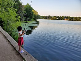
 Fishing at Cronin's Cove
References
- ^ Nedeljkovic, Srdjan (2009). "Crystal Lake: A Brief History". Articles About Crystal Lake. Newton, Massachusetts: Crystal Lake Conservancy. Retrieved April 17, 2020.
- "Crystal Lake". City of Newton. Retrieved 29 June 2021.
- Primack, Richard (2 August 2017). "Swimming (illegally?) in Crystal Lake". Newton Tab. Retrieved 29 June 2021.
- "Crystal Lake". Conservation Properties. Newton, Massachusetts: Newton Conservators. 2020. Retrieved December 18, 2020.
- ^ The Newton Centre Improvement Association (1911). "II. The colonial period". A comprehensive historical sketch of Crystal Lake. Boston, Massachusetts: Stetson Press. pp. 13–21.
- "History of the First Baptist Church in Newton". Newton, Massachusetts: First Baptist Church in Newton. Archived from the original on December 26, 2014. Retrieved April 17, 2020.
- Carter, Allison (2010). "The Lake of Many Names". Articles About Crystal Lake. Newton, Massachusetts: Crystal Lake Conservancy. Retrieved April 17, 2020.
- "Map of Newton 1848". City of Newton.
- ^ "Crystal Lake, Massachusetts". Lakelubbers.com. Retrieved 29 June 2021.
- "Crystal Lake Information and Regulations" (PDF). Archived from the original (PDF) on 12 February 2012.
- "Map of Newton 1875". City of Newton.
- Caldwell-Stair, Lucy (2006). "A stroll around Crystal Lake" (PDF). Articles About Crystal Lake. Newton, Massachusetts: Crystal Lake Conservancy. Retrieved April 17, 2020.
- "The Newton Graphic, March 1941". March 1941.
- "Chap. 0187 An Act dissolving certain corporations".
- ^ "Community Preservation Program Project Appropriations". City of Newton. Retrieved 29 June 2021.
- Rathi, Rachana. "Swirling plans for Crystal Lake". Boston Globe. No. 6 January 2008. Retrieved 29 June 2021.
- "Levingston Cove". City of Newton. Retrieved 29 June 2021.
External links
- U.S. Geological Survey Geographic Names Information System: Crystal Lake (Newton, Massachusetts)
- Crystal Lake Conservancy
- City of Newton
- Newton Conservators
- Lakelubbers