| De Nieuwe Grond | |
|---|---|
| Resort | |
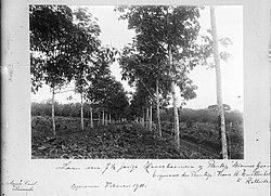
 Rubber trees on De Nieuwe Grond (1911) Rubber trees on De Nieuwe Grond (1911) | |
 Map showing the resorts of Wanica District. De Nieuwe Grond Map showing the resorts of Wanica District. De Nieuwe Grond | |
| Country | |
| District | Wanica District |
| Area | |
| • Total | 38 km (15 sq mi) |
| Population | |
| • Total | 26,161 |
| • Density | 690/km (1,800/sq mi) |
| Time zone | UTC-3 (AST) |
De Nieuwe Grond is a resort in Suriname, located in the Wanica District. Its population at the 2012 census was 26,161. Its main ethnic groups are East Indian, and Creoles. The resort is named after a sugar plantation in 1770. The plantation was already abandoned in 1863, when slavery was abolished, because that year, it was up for public auction. The area used to consist of small scale agriculture with a focus on vegetables and rice, but due to its proximity to Paramaribo, it has become a suburban area with a young population. In 2019, a new bigger market opened in the town.
References
- ^ "Census 2012" (PDF). Stang Makandra. Retrieved 23 May 2020.
- "Surinaamsche Staatkundige Almanach voor den Jaare 1793". Digital Library for Dutch Literature (in Dutch). 1793. Retrieved 23 May 2020.
- "Plantage De Nieuwe Ground". Suriname Plantages (in Dutch). Retrieved 23 May 2020.
- "Diverse News and Advertisements". De West-Indiër via Delpher. 15 July 1863. Retrieved 23 May 2020.
- "Geschiedenis van Wanica deel 3" (in Dutch). Retrieved 23 May 2020.
- "Resultaten 8e Volks- en Woningtelling in Suriname" (PDF). UN Stats (in Dutch). Retrieved 23 May 2020.
- "Feestelijke heropening De Nieuwe Grond markt". GFC Nieuws (in Dutch). Retrieved 23 May 2020.
External links
5°45′2″N 55°12′5″W / 5.75056°N 55.20139°W / 5.75056; -55.20139
This Suriname location article is a stub. You can help Misplaced Pages by expanding it. |
