| Wayamboweg | |
|---|---|
| Resort | |
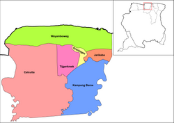
 Map showing the resorts of Saramacca District. Wayamboweg Map showing the resorts of Saramacca District. Wayamboweg | |
| Country | |
| District | Saramacca District |
| Area | |
| • Total | 872 km (337 sq mi) |
| Population | |
| • Total | 1,560 |
| • Density | 1.8/km (4.6/sq mi) |
| Time zone | UTC-3 (AST) |
Wayamboweg is a resort in Suriname, located in the Saramacca District. Its population at the 2012 census was 1,560. The largest ethnic group is East Indian. The resort is mainly agricultural. A rice project has started in late 2017.
In the early 21st century, a high school has been opened. The resort is located near the ocean, and tourism facilities are being developed in the resort. Staatsolie is drilling for oil in the Wayambozwamp.
The village of Smithfield is located in the area.
References
- ^ "Resorts in Suriname Census 2012" (PDF). Retrieved 25 May 2020.
- ^ "Structuur analyse" (PDF). Planning Office Suriname (in Dutch). Retrieved 25 May 2020.
- "November 2017 start experiment met zaaizaad in Saramacca". Dagblad Suriname (in Dutch). Retrieved 25 May 2020.
- "Boerencollectief Noord Saramacca zal Staatsolie voor gerecht slepen". Dagblad Suriname (in Dutch). 7 November 2017. Retrieved 25 May 2020.
| Resorts and places in Saramacca District, Suriname | |
|---|---|
| Calcutta | |
| Groningen |
|
| Jarikaba |
|
| Kampong Baroe | |
| Tijgerkreek | |
| Wayamboweg | |
| Italic denotes the capital *Abandonned settlement | |
5°53′13″N 55°26′48″W / 5.88681°N 55.4468°W / 5.88681; -55.4468
This Suriname location article is a stub. You can help Misplaced Pages by expanding it. |
