| Dorje Lhakpa | |
|---|---|
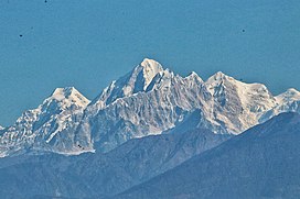
 Dorje Lhakpa seen from Dulalthok. Loenpo Gang is visible further right. Dorje Lhakpa seen from Dulalthok. Loenpo Gang is visible further right. | |
| Highest point | |
| Elevation | 6,966 m (22,854 ft) |
| Prominence | 756 m (2,480 ft) |
| Listing | Mountains of Nepal |
| Coordinates | 28°10′26″N 85°46′45″E / 28.17389°N 85.77917°E / 28.17389; 85.77917 |
| Geography | |
 | |
| Location | Langtang National Park, Nepal |
| Parent range | Himalayas |
| Climbing | |
| Easiest route | West Ridge |
Dorje Lhakpa is a mountain in the Jugal Himal, southeast of Langtang valley in Nepal.
Visible also from Kathmandu valley it has an elegant pyramid-shaped figure and is an ideal target for photographers and mountaineers. Considered by many of intermediate difficulty with easiest route from the west ridge. Its climb is offered by many trekking and mountaineering agencies in Nepal.
Climbing history

In 1986, a German–Nepalese expedition reached the mountain from the southern Balephi Khola and attempt to climb it over the west ridge. On 11 July 1986, Helmut Müller, Bernd Mayer reached the summit separately; Müller is forced to bivouac at 6,700 m (22,000 ft) while descending.
In 1992, Carlos Buhler made a solo climb of Dorje Lhakpa. Buhler did not intend initially to climb solo. The climb became a solo of the West Ridge after Carlos' partner, Jon Aylward, became ill at base camp.
A team from the Yorkshire Ramblers' Club attempted the first British ascent by the west ridge in 1995; deteriorating conditions forced the team to turn back at 6,100m.
References
- ^ Carter, H. A. (1985). "Classification of the Himalaya" (PDF). American Alpine Journal. 27 (59): 109–141.
- "Dorje Lhakpa". Peakbagger.com. Retrieved 15 June 2020.
- Oeser, Thomas (1987). "Dorje Lhakpa". American Alpine Journal. American Alpine Club. Retrieved 15 June 2020.
- Buhler, Carl (1993). "Alone on Dorje Lhakpa". American Alpine Journal. 35 (67). American Alpine Club. Retrieved 15 June 2020.
- "Yorkshire Ramblers Club Dorje Lakpa". Mount Everest Foundation. Retrieved 2025-01-06.