| Loenpo Gang | |
|---|---|
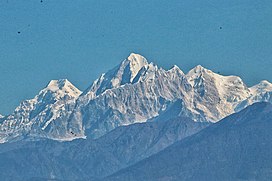
 Loenpo Gang (right) behind Dorje Lhakpa (centre) Loenpo Gang (right) behind Dorje Lhakpa (centre) | |
| Highest point | |
| Elevation | 6,979 m (22,897 ft) |
| Prominence | 1,019 m (3,343 ft) |
| Parent peak | Nyanang Ri |
| Listing | |
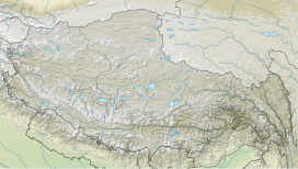
| Coordinates | 28°11′44″N 85°47′58″E / 28.19556°N 85.79944°E / 28.19556; 85.79944 |
| Geography | |
   | |
| Countries | Nepal and China |
| Parent range | Himalayas |
| Climbing | |
| First ascent | May 3, 1962 |
Loenpo Gang (also known as Lönpo Gang) is a mountain peak in the Himalayas on the border of Nepal and the Tibet Autonomous Region of People's Republic of China.
Location
The peak is located at 6,979 m (22,897 ft) above sea level. It is part of Jugal Himal range which also consists of following peaks Dorje Lhakpa and Phurbi Chyachu. The prominence is 1,042 m (3,419 ft).
Climbing history
The first ascent was made on May 3, 1962, by a Japanese team consisting of Tadashi Morita, and Kazunari Yasuhisa.
In 1988, a team of South Korean doctors from Chonnam National University Medical School climbed the peak from a new route, and reached the summit on September 27. The team consisted of Ryong Yoon-Jae, Cho Suk-Phil, Kwon Hyeon, Hong Woon-Ki, Lee Jeong-Hoon, and Kim Soo-Hyeon.
References
- ^ "Loenpo Gang". Peakbagger.com. Retrieved 2022-04-22.
- "Loenpo Gang". PeakVisor. Retrieved 2022-04-22.
- "Leonpo Gang". nepalhimalpeakprofile.org. Retrieved 2022-04-22.
- "Asia, Nepal, Loenpo Gang". American Alpine Journal. American Alpine Club. 1988. Retrieved 2022-04-22.
This article related to a mountain or hill in China is a stub. You can help Misplaced Pages by expanding it. |
This article related to a mountain or hill in Nepal is a stub. You can help Misplaced Pages by expanding it. |