| Dunham Massey | |
|---|---|
 | |
| General information | |
| Location | Dunham Massey, Metropolitan Borough of Trafford England |
| Grid reference | SJ728885 |
| Platforms | 2 |
| Other information | |
| Status | Disused |
| History | |
| Original company | Warrington and Stockport Railway |
| Pre-grouping | London and North Western Railway |
| Post-grouping | London Midland and Scottish Railway London Midland Region of British Railways |
| Key dates | |
| 1 November 1854 | Opened as Warburton |
| June 1856 | Renamed Warburton and Dunham |
| October 1856 | Renamed Dunham |
| April 1861 | Renamed Dunham Massey |
| 10 September 1962 | Closed |
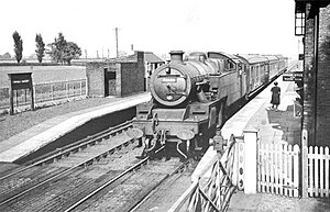
Dunham Massey railway station was a stop on the Warrington and Altrincham Junction Railway. It served the village of Dunham Massey, in Cheshire (now Greater Manchester), England. The station opened in 1854 and closed in 1962.
History
The Warrington and Altrincham Junction Railway (W&AJR) built its railway line from Warrington Arpley to Skelton Junction, via Latchford and Lymm, during 1852–53 and passenger train services commenced on 1 November 1853. There were six intermediate stations provided along the line's length including that at Dunham Massey, which was opened in June 1854. The station was located on the south side of Henshall Lane.
The station was named Warburton from its opening until June 1856 when it became Warburton and Dunham. In October 1856, it was renamed Dunham; it finally became Dunham Massey in April 1861, which was retained until closure.
The W&AJR changed its name to the Warrington and Stockport Railway on 4 August 1853, before the line was completed and that company was absorbed into the London and North Western Railway (LNWR) on 15 July 1867.
The LNWR was amalgamated into the London Midland and Scottish Railway (LMS) on 1 January 1923. The LMS continued to operate the passenger train service through Dunham Massey but, by July 1946, only eight trains per day in each direction stopped at the station. LMS was nationalised on 1 January 1948 and operations on the line were vested in British Railways' London Midland Region (LMR). In January 1956, the service to Dunham Massey was eight trains in each direction, with the fare for the eleven miles single journey to Manchester being 1s 7d (8p).
Passenger services along the line were withdrawn and the station was closed by British Railways on 10 September 1962. Freight trains continued to use the line until 7 July 1985, when the need for extensive repairs to the Latchford Viaduct caused the line to be closed.
Services
The main LNWR train service through Dunham Massey station was from Liverpool Lime Street via Warrington Arpley to Broadheath, where trains joined the Manchester South Junction and Altrincham Railway and continued via Sale to Manchester London Road. In July 1922, the LNWR operated fifteen passenger trains in each direction on weekdays, with eleven of these serving the full length of the line between Liverpool and Manchester.
| Preceding station | Disused railways | Following station | ||
|---|---|---|---|---|
| Heatley & Warburton | LNWR Warrington & Stockport Railway |
Broadheath |
The site today
The station building survives in use as a domestic dwelling and the trackbed forms part of the Trans Pennine Trail.
References
Citations
- Fields, Gilbert & Knight 1980, Photo 255
- Butt, R.V.J. (1995). The Directory of Railway Stations, Patrick Stephens Ltd, Sparkford, ISBN 1-85260-508-1, p. 117.
- Paul Shannon & John Hillmer (2003). British Railways Past and Present no 40 Cheshire. Kettering: Past & Present Publishing Ltd. p. 95. ISBN 1-85895-232-8.
- ^ Awdry 1990, p. 108
- ^ Butt 1995, p. 241
- ^ Butt 1995, p. 85
- ^ Wright, Paul (17 May 2017). "Station name: Dunham Massey". Disused Stations. Retrieved 11 October 2024.
- Awdry 1990, p. 88
Sources
- Awdry, Christopher (1990), Encyclopedia of British Railway Companies, Patrick Stephens Ltd, ISBN 1-85260-049-7
- Butt, R.V.J. (1995), The Directory of Railway Stations, Patrick Stephens Ltd, ISBN 1-85260-508-1
- Fields, N; Gilbert, A C; Knight, N R (1980). Liverpool to Manchester into the Second Century. Manchester Transport Museum Society. ISBN 0-900857-19-6.
53°23′34″N 2°24′45″W / 53.3928°N 2.4125°W / 53.3928; -2.4125
Categories: