| Formoso do Araguaia | |
|---|---|
| Municipality | |
| The Municipality of Formoso do Araguaia | |
 A lake in Formoso do Araguaia A lake in Formoso do Araguaia | |
 Seal Seal | |
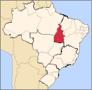
 Location of Formoso do Araguaia in the state of Tocantins Location of Formoso do Araguaia in the state of Tocantins | |
 | |
| Coordinates: 11°48′09″S 49°31′42″W / 11.80250°S 49.52833°W / -11.80250; -49.52833 | |
| Country | |
| Region | North |
| State | |
| Founded | October 1, 1963 |
| Government | |
| • Mayor | Pedro Rezende (PTB) |
| Area | |
| • Total | 13,423.256 km (5,182.748 sq mi) |
| Elevation | 240 m (790 ft) |
| Population | |
| • Total | 18,399 |
| • Density | 1.4/km (3.6/sq mi) |
| Time zone | UTC−3 (BRT) |
| HDI (2000) | 0.710 – medium |
Formoso do Araguaia is a municipality in the state of Tocantins in the Northern region of Brazil. It is the largest municipality by area in that state.
See also
References
- "IBGE 2020". Retrieved 26 January 2021.
- "Archived copy". Archived from the original on 2009-10-03. Retrieved 2009-12-17.
{{cite web}}: CS1 maint: archived copy as title (link) - UNDP - "Divisão Territorial do Brasil" (in Portuguese). Divisão Territorial do Brasil e Limites Territoriais, Instituto Brasileiro de Geografia e Estatística (IBGE). July 1, 2008. Archived from the original on 2020-07-29. Retrieved December 17, 2009.
- "Produto Interno Bruto dos Municípios 2002-2005" (PDF) (in Portuguese). Instituto Brasileiro de Geografia e Estatística (IBGE). December 19, 2007. Archived from the original (PDF) on October 2, 2008. Retrieved December 17, 2009.
This Tocantins, Brazil location article is a stub. You can help Misplaced Pages by expanding it. |
