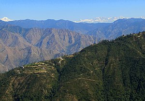
The Garhwal Himalayas are mountain ranges located in the Indian state of Uttarakhand.
Geology
This range is also a part of the Himalayan Sivalik Hills, the outer most hills of the Himalaya located in Himachal Pradesh and Uttarakhand.
Major peaks of Garhwal Himalayas
Demographics
The cities which are included in these ranges are Pauri, Tehri, Uttarkashi, Rudraprayag, Chamoli, and Chota Char Dham pilgrimage namely Gangotri, Yamunotri, Badrinath and Kedarnath. Some of the sites of the location are the hill stations of Mussoorie, Dhanaulti, Auli, Chakrata, Chopta, UNESCO World Heritage Site, Nanda Devi and Valley of Flowers National Parks is also located in Garhwal Himalaya.
See also
References
- Rawat, Ajay S. (November 2002). Garhwal Himalayas: A Study in Historical Perspective. Indus Publishing. ISBN 978-81-7387-136-8.
- Kapadia, Harish (1999). Across Peaks & Passes in Garhwal Himalaya. Indus Publishing. ISBN 978-81-7387-097-2.
- "an empirical study of Garhwal Himalaya". ResearchGate. Retrieved 12 July 2021.
- Chisholm, Hugh, ed. (1911). "Siwalik Hills" . Encyclopædia Britannica. Vol. 25 (11th ed.). Cambridge University Press.
30°37′01″N 78°54′04″E / 30.6170°N 78.9010°E / 30.6170; 78.9010
| State of Uttarakhand | |||||||||||||||||||
|---|---|---|---|---|---|---|---|---|---|---|---|---|---|---|---|---|---|---|---|
| State capitals: legislative: Dehradun (winter); Bhararisain (summer); judicial: Nainital | |||||||||||||||||||
| Government |
| ||||||||||||||||||
| History |
| ||||||||||||||||||
| Geography and ecology |
| ||||||||||||||||||
| Demographics |
| ||||||||||||||||||
| Administrative divisions |
| ||||||||||||||||||
| Politics | |||||||||||||||||||
| Tourism |
| ||||||||||||||||||
| Sports | |||||||||||||||||||
| Other topics | |||||||||||||||||||
| Districts |
| ||||||||||||||||||
| Major cities | |||||||||||||||||||