Municipality in Brandenburg, Germany
Gerdshagen is a municipality in the Prignitz district, in Brandenburg , Germany .
Demography
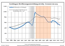
Development of Population since 1875 within the Current Boundaries (Blue Line: Population; Dotted Line: Comparison to Population Development of Brandenburg state; Grey Background: Time of Nazi rule; Red Background: Time of Communist rule) Gerdshagen: Population development Year Pop. ±% p.a. 1875 427 — 1890 359 −1.15% 1910 467 +1.32% 1925 609 +1.79% 1933 566 −0.91% 1939 506 −1.85% 1946 961 +9.60% 1950 926 −0.92% 1964 816 −0.90% 1971 815 −0.02% 1981 642 −2.36% 1985 612 −1.19% 1989 628 +0.65% 1990 626 −0.32% 1991 603 −3.67% 1992 610 +1.16% 1993 632 +3.61% 1994 654 +3.48% 1995 669 +2.29% 1996 670 +0.15%
Year Pop. ±% p.a. 1997 657 −1.94% 1998 658 +0.15% 1999 658 +0.00% 2000 651 −1.06% 2001 648 −0.46% 2002 631 −2.62% 2003 635 +0.63% 2004 629 −0.94% 2005 612 −2.70% 2006 589 −3.76% 2007 584 −0.85% 2008 573 −1.88% 2009 547 −4.54% 2010 535 −2.19% 2011 537 +0.37% 2012 540 +0.56% 2013 530 −1.85% 2014 520 −1.89% 2015 505 −2.88% 2016 499 −1.19%
References
Landkreis Prignitz Wahl der Bürgermeisterin / des Bürgermeisters . Retrieved 10 July 2024.
"Bevölkerungsentwicklung und Bevölkerungsstandim Land Brandenburg Dezember 2022" (PDF). Amt für Statistik Berlin-Brandenburg Population Projection Brandenburg at Wikimedia Commons
Towns and municipalities in Prignitz
Coat of Arms of Prignitz district
Categories :
Text is available under the Creative Commons Attribution-ShareAlike License. Additional terms may apply.
**DISCLAIMER** We are not affiliated with Wikipedia, and Cloudflare.
The information presented on this site is for general informational purposes only and does not constitute medical advice.
You should always have a personal consultation with a healthcare professional before making changes to your diet, medication, or exercise routine.
AI helps with the correspondence in our chat.
We participate in an affiliate program. If you buy something through a link, we may earn a commission 💕
↑


