Human settlement in England
| Gravenhurst | |
|---|---|
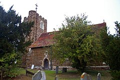
 St Mary's church St Mary's church | |
 | |
| Population | 595 (2011 Census) |
| OS grid reference | TL121143 |
| Unitary authority | |
| Ceremonial county | |
| Region | |
| Country | England |
| Sovereign state | United Kingdom |
| Post town | BEDFORD |
| Postcode district | MK45 |
| Dialling code | 01462 |
| Police | Bedfordshire |
| Fire | Bedfordshire and Luton |
| Ambulance | East of England |
| UK Parliament | |
| |
Gravenhurst is a civil parish located in the Central Bedfordshire district of Bedfordshire, England.
The parish includes Lower Gravenhurst, Upper Gravenhurst, as well as the hamlet of Ion.
Features of Gravenhurst include St. Mary's Church, which was built during the 14th century.
History
Gravenhurst was recorded in the Domesday Book as Crauenhest. The entry reads: Crauenhest: William from Hugh de Beauchamp. The parish was formed on 24 March 1888 from "Lower Gravenhurst" and "Upper Gravenhurst".
Education
| This section needs expansion. You can help by adding to it. (January 2025) |
It is in the catchment zone for Robert Bloomfield Academy.
References
- "Civil Parish population 2011". Neighbourhood Statistics. Office for National Statistics. Retrieved 8 November 2016.
- "'Guide to Bedfordshire Parishes'". Bedfordshire.gov.uk. Archived from the original on 13 February 2012. Retrieved 6 August 2012.
- "'Gravenhurst history timeline'". Galaxy.bedfordshire.gov.uk. 15 March 2007. Archived from the original on 22 February 2012. Retrieved 6 August 2012.
- "Bedfordshire A-H". The Domesday Book Online. Retrieved 31 January 2023.
- "Ampthill Registration District". UKBMD. Retrieved 31 January 2023.
- "Admission Arrangements September 2025" (PDF). Bedfordshire Schools Trust. p. 14/35. Retrieved 3 January 2025. - Map is on p. 34/35.
External links
![]() Media related to Gravenhurst, Bedfordshire at Wikimedia Commons
Media related to Gravenhurst, Bedfordshire at Wikimedia Commons
This Bedfordshire location article is a stub. You can help Misplaced Pages by expanding it. |