 Hangzhou–Ruili Expressway
 | ||||
|---|---|---|---|---|
| 杭州-瑞丽高速公路 | ||||
| Hangrui Expressway 杭瑞高速公路 | ||||
 | ||||
| Route information | ||||
| Part of | ||||
| Length | 2,935 km (1,824 mi) | |||
| Major junctions | ||||
| East end | ||||
| West end | Ruili, Yunnan | |||
| Location | ||||
| Country | China | |||
| Highway system | ||||
| ||||
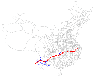
The Hangzhou–Ruili Expressway (Chinese: 杭州—瑞丽高速公路), designated as G56 and commonly referred to as the Hangrui Expressway (Chinese: 杭瑞高速公路) is an expressway in China that connects the cities of Hangzhou, Zhejiang, and Ruili, Yunnan, a city on the border with Burma. When complete, it will be 2,935 km (1,824 mi) in length. Running through mountainous terrain, it is notable for its several tunnels and bridges, including the very high Duge Bridge, Puli Bridge and Dimuhe River Bridge.
The expressway is complete in the provinces of Zhejiang, Anhui, and Jiangxi. The entire expressway in the provinces of Hubei, Hunan, Guizhou, and Yunnan is under construction except for sections from Changde to Jishou in Hunan and from the Guizhou border to Baoshan in Yunnan.
At Ruili, there will be a border crossing to Muse, Myanmar and National Highway 3.
Route

Hangzhou, Huangshan, Jingdezhen, Jiujiang, Xianning, Yueyang, Changde, Jishou, Zunyi, Bijie, Liupanshui, Qujing, Kunming, Chuxiong, Dali, Ruili
Spurs
- G5611 Dali–Lijiang Expressway: connecting to Lijiang
See also
- Burma Road, whose path the G56 often follows
References
- ^ G56 杭瑞高速 (in Chinese)
