| Huaraz Waras | |
|---|---|
| District | |
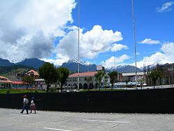
 Main square in Huaraz with the Cordillera Blanca in the background Main square in Huaraz with the Cordillera Blanca in the background | |
| Country | |
| Region | Ancash |
| Province | Huaraz |
| Capital | Huaraz |
| Government | |
| • Mayor | Eliseo Rori Mautino Ángeles (2019-2022) |
| Area | |
| • Total | 432.99 km (167.18 sq mi) |
| Elevation | 3,052 m (10,013 ft) |
| Population | |
| • Total | 52,592 |
| • Density | 120/km (310/sq mi) |
| Time zone | UTC-5 (PET) |
| UBIGEO | 020101 |
Huaraz District is one of twelve districts of the province Huaraz in Peru.
Geography
The Cordillera Blanca and the Cordillera Negra traverse the district. Some of the highest mountains of the district are listed below:
- Antap'iti
- Kashan
- Kayish
- Kima Rumi
- Map'arahu
- Puka Hirka
- Qarwakancha
- Wamash Punta
- Wamashrahu
References
- (in Spanish) Instituto Nacional de Estadística e Informática. Banco de Información Distrital Archived 2008-04-23 at the Wayback Machine. Retrieved April 11, 2008.
- escale.minedu.gob.pe - UGEL map of the Huaraz Province (Ancash Region)
See also
9°32′S 77°32′W / 9.533°S 77.533°W / -9.533; -77.533
This Ancash Region geography article is a stub. You can help Misplaced Pages by expanding it. |