| Ismoil Somoni Peak | |
|---|---|
| Stalin Peak, Communism Peak | |
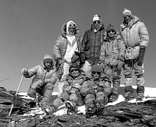
 Ismoil Somoni Peak (then known as Communism Peak) taken in 1989. Ismoil Somoni Peak (then known as Communism Peak) taken in 1989. | |
| Highest point | |
| Elevation | 7,495 m (24,590 ft) Ranked 50th |
| Prominence | 3,402 m (11,161 ft) Ranked 54th |
| Listing | Country high point Ultra |
| Coordinates | 38°56′36″N 72°00′58″E / 38.94333°N 72.01611°E / 38.94333; 72.01611 |
| Geography | |
 | |
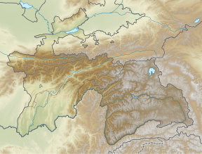
| Location | Northwestern Gorno-Badakhshan, Tajikistan |
| Parent range | Pamirs |
| Climbing | |
| First ascent | 3 September 1933 by Yevgeniy Abalakov and Nikolay Gorbunov. |
| Easiest route | rock/snow/ice climb |

Ismoil Somoni Peak (Tajik: Қуллаи Исмоили Сомонӣ, romanized: Qulla-i Ismō‘il-i Sōmōnî/Qullaji Ismojili Somonī; Persian: قلّهٔ اسماعیل سامانی; Russian: Пик Исмои́ла Сомони́, romanized: Pik Ismoíla Somoní) is the highest mountain in Tajikistan. Because it was within the territory of the former Russian Empire and the former Soviet Union, it was the highest mountain in the Russian Empire and Soviet Union before Tajikistan became independent. The mountain is named after Ismail Samani, a ruler of the Samanid dynasty. It is located in the Pamir Range.
Name
When the existence of a peak in the Soviet Pamir Mountains higher than Lenin Peak was first established in 1928, the mountain was tentatively identified with Mount Garmo. However, as the result of the work of further Soviet expeditions, it became clear by 1932 that they were not the same, and in 1933 the new peak, in the Academy of Sciences Range, was named Stalin Peak (Russian: Пик Ста́лина, romanized: Pik Stálina), after Joseph Stalin. In 1962, as part of Khrushchev's nationwide de-Stalinization process, the name was changed to Communism Peak (Tajik: Пики Коммунизм, romanized: Piki Komunizm Russian: Пик Коммуни́зма, romanized: Pik Kommunízma), a name by which it is still commonly known. The name Communism Peak was officially dropped in 1998 in favour of the current name, commemorating the 9th-10th century Samanid emir, Ismail Samani.
History
By the end of the 1880s, a Russian expedition, led by V.F. Oshanin, conducted research named various regions in the area. He noted in his diary: "I believe that the eastern peak has a height of up to 25,000 feet (7,600 metres)." The central Pamirs would continue to be visited by the expeditions of Kosineko, Korzhenevsky, Lipsky, Novitsky, Musketov, and others, but they failed to reach the Academy of Sciences Range.
In 1913, the central part of the Pamirs was explored by an expedition led by the German mountain explorer and climber Willi Rickmer Rickmers. The expedition penetrated the upper reaches of the Obikhingou River, where they saw a 6650 m peak. It was given the name Garmo Peak, according to the name given by the Tajiks from Pashimgar. Subsequent expeditions to the area of the Range of the Academy of Sciences took place in Soviet times.
In 1928, the long-term Tajik-Pamir expedition of the Academy of Sciences of the USSR began to operate, which began with the Soviet-German expedition with the participation of Willy Rickmers. As a result of topographic survey, it was found that one of the peaks visible in the west of the Fedchenko glaciers reaches a height of 7495 m. Having compared the survey results with a schematic map compiled by Korzhenevsky back in 1925, and with other data, the members of the expedition of the Academy of Sciences decided that this peak is Garmo Peak, which was mapped by the German expedition of 1913. However, this led to the "mystery of the Garmo", as there was a discrepancy between the heights: 6650 m and 7495 m. This was solved only during the expeditions of 1931 and 1932, when two detachments of climbers and topographers (led by Gorbunov and Krylenko) penetrated the area from the east and from the west. The 6650 m peak was determined to be the real Garmo, and the unnamed 7495 m peak was conclusively discovered and mapped, and given the name Stalin Peak in honor of Stalin's upcoming 55th birthday.
The first ascent (to the then Stalin Peak) was made on 3 September 1933 by the Soviet mountaineer Yevgeniy Abalakov, during the Tajik-Pamir expedition of 1933.
The first woman to ascend to the peak was Lyudmila Agranovskaya in 1969.
The first winter ascent was made in February 1986 by 24 climbers (7 from Uzbekistan, and 17 from the rest of the USSR).
See also
- List of highest mountains on Earth
- Lenin Peak
- Peak Korzhenevskaya
- Mount Garmo
- Patkhor Peak
- List of elevation extremes by country
- Extreme points of Tajikistan
References
- ^ "Territorial and border issues". Ministry of Foreign Affairs of the Republic of Tajikistan. 1 March 2010. Retrieved 31 January 2020.
The lowest spot of the country is on the height of 300 meters and the highest spot is on the height of 7495 meters above sea level. on the South-East – Pamir (one of the highest spot of the Earth – peak Somoni, with the height of 7495 meters)
- ^ Scheffel, Richard L.; Wernet, Susan J., eds. (1980). Natural Wonders of the World. United States of America: Reader's Digest Association, Inc. p. 104. ISBN 0-89577-087-3.
- ^ "General information about Tajikistan". Conference on Interaction and Confidence-Building Measures in Asia. Archived from the original on 31 January 2020. Retrieved 31 January 2020.
Tajikistan is a typical mountainous country with absolute heights from 300 to 7495 m. 93% of its territory is occupied by mountains belonging to the highest mountain systems of Central Asia – Tien-Shan and Pamir. Many peaks in Tajikistan are among the highest in the world, rising to a maximum of 7,495 m (24,590 ft) at Ismoil Somoni Peak (formerly Peak Communism).
- ^ "Tajikistan". The World Factbook. Archived from the original on 10 March 2020. Retrieved 30 January 2020.
highest point: Qullai Ismoili Somoni 7,495 m Geography – landlocked; highest point, Qullai Ismoili Somoni (formerly Communism Peak), was the tallest mountain in the former USSR
- ^ Sally N. Cummings, ed. (2010). Symbolism and Power in Central Asia: Politics of the Spectacular. Routledge. p. 67. ISBN 978-0-415-57567-6 – via Google Books.
In 1933 the USSR'S Highest Mountain, Peak Stalin ((7,495 m), subsequently renamed Peak Communism and ultimately Ismail Somoni) was climbed as part of a large expedition, the Tajikistan-Pamirs-expedition (TPE). Mount Stalin was the highest point in the USSR
- ^ Martin Hannan (2011). Harvey Wallbangers and Tam O'Shanters A Book of Eponyms. Kings Road. pp. 45–46. ISBN 978-1843588696.
Ismoil Somoni Peak, Formerly Stalin Peak and Communism Peak, the highest mountain in the former Soviet Union territories is now called after Ismoil Somoni or Ismail Samani (d. 907), leader of the Samani dynasty which conquered the region now known as the country of Tajikistan in which the mountain rises to a height of 7,495m (24,590 ft).
- Stephen K. Batalden; Sandra L. Batalden (1997). The Newly Independent States of Eurasia Handbook of Former Soviet Republics (2 ed.). Oryx Press. ISBN 0-89774-940-5 – via Internet Archive.
Highest elevation
24,590 ft (Kommunizm Peak, in the Pamir Range) - ^ USSR A Reference Book of Facts and Figures. London: Farleigh Press Ltd. 1956. p. 16 – via Internet Archive.
The tallest peaks (in feet above sea-level):
Stalin Peak (Pamirs) 24,583; - ^ V. H. Hillyer; E. G. Huey (1966). The Orient. New York: Meredith Press. p. 102 – via Internet Archive.
The highest peak, Stalin Peak, 24,590 feet, is here.
- "Альпинисты Северной Столицы. Горы" (in Russian).
- "Последняя загадка Памирских гор" (in Russian).
- Kalinin, G. (1983). Фортамбек и его вершины (in Russian). Tashkent.
{{cite book}}: CS1 maint: location missing publisher (link) - Яценко, В. С. (1950). В горах Памира. Geografgiz.
- Лукницкий, П. Н. Таджикская экспедиция. Средняя Азия.
- "История экспедиций". Archived from the original on 15 November 2012.
- "Альпинисты Северной Столицы".
- Захаров, П.П. "Что мы знаем об альпинисте Вилли Рикмер-Рикмерсе?".
- The Great Soviet Encyclopaedia. Communizma Peak. Also Pik Kommunzma at summitpost.org accessed 3Nov2016.
- "Рекорды в мире природы" (in Russian).
- "39 Первопрохождений на пик Коммунизма" (in Russian). Archived from the original on 4 November 2012.
External links
- Route description and climbing map
- "Pik Kommunizma". SummitPost.org.
- "Ismoil Somoni Peak". Peakware.com. Archived from the original on 2016-03-04.