Dam in Gobichettipalayam Taluk, Tamil Nadu
| Kodiveri dam | |
|---|---|
 | |
| Official name | Kodiveri anaicut |
| Country | India |
| Location | Akkarai Kodiveri, Gobichettipalayam Taluk, Tamil Nadu |
| Coordinates | 11°28′23″N 77°17′47″E / 11.47306°N 77.29639°E / 11.47306; 77.29639 |
| Purpose | Irrigation |
| Status | In use |
| Opening date | 1125 AD (canal) 17th century (dam) |
| Owner(s) | Government of Tamil Nadu |
| Dam and spillways | |
| Impounds | Bhavani River |
| Reservoir | |
| Creates | Kodiveri |
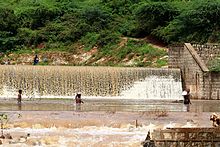
Kodiveri Dam is a masonry dam located on the Bhavani river in Gobichettipalayam taluk, Erode district in the Indian state of Tamil Nadu. The dam is situated along the State Highway 15 about 15 km (9.3 mi) from Gobichettipalayam towards Sathyamangalam in the western region of the state.
Etymology
The name ‘Kodiveri’ originated from ‘kodivari’ meaning tiger in Tamil. This might be due to the presence of the dam in a forest area where a number of tigers lived.
urali semba vettuva jeyangonda chola Kongalvan Vettuva Gounder King built the dam in the year 1125 AD. A 20-foot rock wall was carved out in order to build the dam. Iron bars were then used to interlock the stones, and lead was used as mortar. The small waterfall created by the flowing river water from the other side of the dam is purely a delight to the eyes.
Due to non-availability of rocks in Kodiveri, rocks were quarried from Kalkadampur (Kambatrayan Hill), 10 km north of Sathyamangalam. Skilled masons from Odisha, Karnataka and Andhra Pradesh were brought in for the construction work.
The dam was completed in about 3 years. On the day of opening the dam, it was arranged that the king would come. But, a sudden flood broke out and the dam was completely washed away. The information went to the king. He again ordered the dam to be built. Accordingly, the dam was built again in about one and a half years. When the king was about to open the dam again, there was another flood. Thousands of people died this time.
The king, who was very saddened, said, “Pannari Amman and Nanjundeshwar are preventing me from going there. I and my family will not come there from now on, he says. Also, the one who ordered the construction of the dam again tells him to ensure that the information does not reach him after the construction of the dam is completed. Accordingly, the dam was completed for the third time. That is the flag root dam which is still standing today. Accordingly, a dam was constructed with a length of 151 meters and a width of 30 feet.
Hydrography
The dam is built on the Bhavani river. Two channels arise from the dam, Arrakkankottai on the northern side of Bhavani river and Thadapalli on the southern side. Lands north of Gobichettipalayam are irrigated by Thadapalli channel and cultivation of sugarcane and paddy are predominant in this area. The dam irrigates an area of 24,504 acres (9,916 ha).
Recreation
The dam is a popular tourist spot. The park, associated play area and coracle rides are the main attractions.
See also
References
- "A watery break from routine". Covai Post. 17 August 2015. Retrieved 25 August 2023.
- Saravanan, Velayutham (2020). Water and the Environmental History of Modern India. Bloomsbury Publishing. ISBN 9781350130845.
- "Water available in Bhavani Sagar reservoir sufficient for second crop". The Hindu. 8 December 2015. Retrieved 23 August 2023.
- "Water released into canals to irrigate 24,504 acres". The Hindu. 1 August 2015. Retrieved 25 August 2023.
- "Water from Kodiveri Check Dam released". The Hindu. 29 June 2013. Retrieved 25 August 2023.
- "Kodiveri Dam, a weekend tourist destination in Erode district". The Hindu. 9 June 2014. Retrieved 25 August 2023.
External links
| Kongu Nadu | |||||||||||||||
|---|---|---|---|---|---|---|---|---|---|---|---|---|---|---|---|
| State |  | ||||||||||||||
| Districts | |||||||||||||||
| Major towns | |||||||||||||||
| Languages | |||||||||||||||
| Geographical features |
| ||||||||||||||
| Geographical Indications |
| ||||||||||||||
| History | |||||||||||||||
This article about a dam, floodgate or canal in India is a stub. You can help Misplaced Pages by expanding it. |
