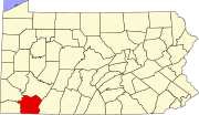
This is a list of the Pennsylvania state historical markers in Fayette County.
This is intended to be a complete list of the official state historical markers placed in Fayette County, Pennsylvania by the Pennsylvania Historical and Museum Commission (PHMC). The locations of the historical markers, as well as the latitude and longitude coordinates as provided by the PHMC's database, are included below when available. There are 49 historical markers located in Fayette County.
Map all coordinates using OpenStreetMapDownload coordinates as:
Historical markers
| Marker title | Image | Date dedicated | Location | Marker type | Topics |
|---|---|---|---|---|---|
| Albert Gallatin | 
|
November 23, 1946 | Junction US 119 & PA 166, north of Point Marion (MISSING) | Roadside | Government & Politics, Government & Politics 18th Century |
| Alliance Furnace | 
|
November 22, 1946 | Banning & Layton Roads, Perryopolis 40°06′05″N 79°42′34″W / 40.10128°N 79.709541°W / 40.10128; -79.709541 (Alliance Furnace) |
Roadside | Business & Industry, Furnaces, Iron, Military, Native American |
| Alliance Furnace | 
|
November 22, 1946 | PA 819, 1 mile north of Dawson (MISSING) | Roadside | Business & Industry, Furnaces, Iron, Military, Native American |
| Benjamin Wells | 
|
July 19, 1994 | US 119 at North 7th Street, Connellsville 40°01′06″N 79°35′59″W / 40.01847°N 79.59966°W / 40.01847; -79.59966 (Benjamin Wells) |
City | Government & Politics, Government & Politics 18th Century, Military, Whiskey Rebellion |
| Birthplace of John Alfred Brashear (1840-1920) - PLAQUE | 
|
May 1943 | Front Street, Brownsville | Plaque | Medicine & Science, Professions & Vocations |
| Boatbuilding Center/Steamboat Enterprise | 
|
August 27, 1994 | Dunlap's Creek Park, Market Street & Bank Street, Brownsville 40°01′17″N 79°53′18″W / 40.021393°N 79.888297°W / 40.021393; -79.888297 (Boatbuilding Center/Steamboat Enterprise) |
Roadside | Business & Industry, Transportation |
| Braddock Park | 
|
November 23, 1946 | At park, National Road (US 40), 2.5 miles northwest of Farmington 39°49′55″N 79°36′03″W / 39.832007°N 79.600891°W / 39.832007; -79.600891 (Braddock Park) |
Roadside | French & Indian War, Military, Roads |
| Braddock Road (Dunbar's Camp) | 
|
June 17, 1952 | Jumonville Rd. (SR 2021), ~3 miles north of National Road (US 40), Jumonville 39°52′57″N 79°38′46″W / 39.88237°N 79.64622°W / 39.88237; -79.64622 (Braddock Road (Dunbar's Camp)) |
Roadside | French & Indian War, Military, Roads |
| Braddock Road (Rock Fort Camp) | 
|
June 17, 1952 | National Road (US 40) at Jumonville Road (SR 2021), across from Summit Inn & Restaurant, Summit 39°51′00″N 79°39′25″W / 39.84992°N 79.65705°W / 39.84992; -79.65705 (Braddock Road (Rock Fort Camp)) |
Roadside | French & Indian War, George Washington, Military, Native American, Roads |
| Braddock Road (Stewart's Crossing) | 
|
August 26, 1952 | US 119, .2 mile south of Connellsville 40°00′02″N 79°36′19″W / 40.00055°N 79.60515°W / 40.00055; -79.60515 (Braddock Road (Stewart's Crossing)) |
Roadside | Forts, French & Indian War, Military, Roads |
| Braddock Road (Twelve Springs Camp) | 
|
May 21, 1952 | National Road (US 40), 3.5 miles southeast of Farmington 39°46′40″N 79°30′03″W / 39.77768°N 79.50087°W / 39.77768; -79.50087 (Braddock Road (Twelve Springs Camp)) |
Roadside | American Revolution, Forts, Military, Roads, Transportation |
| Brashear House | 
|
November 22, 1946 | 6th & Market Streets (US 40), Brownsville 40°01′18″N 79°52′45″W / 40.021635°N 79.879162°W / 40.021635; -79.879162 (Brashear House)) |
Roadside | Buildings, Business & Industry, Education, Houses & Homesteads, Professions & Vocations, Inns & Taverns |
| Brownsville | 
|
November 22, 1946 | National Pike at south end of Brownsville 40°01′06″N 79°52′45″W / 40.01833°N 79.87914°W / 40.01833; -79.87914 (Brownsville)) |
Roadside | Cities & Towns, Forts, Military, Paths & Trails, Roads |
| Coke Ovens | 
|
November 22, 1946 | PA 51 just west of Perryopolis 40°04′16″N 79°45′43″W / 40.071117°N 79.761983°W / 40.071117; -79.761983 (Coke Ovens)) |
Roadside | Business & Industry, Coal, Iron, Steel |
| Col. William Crawford | 
|
n/a | US 119 at North 7th Street, .2 mile south of Connellsville 40°01′09″N 79°35′58″W / 40.01908°N 79.5994°W / 40.01908; -79.5994 (Col. William Crawford) |
Roadside | American Revolution, French & Indian War, George Washington, Military, Native American |
| Colonel William Crawford - PLAQUE | 
|
October 1918 | South Pittsburgh Street & East South Street, Connellsville 40°00′58″N 79°35′19″W / 40.015973°N 79.588653°W / 40.015973; -79.588653 (Colonel William Crawford) |
Plaque | American Revolution, George Washington, Military |
| Connellsville Coke Region | 
|
March 15, 2007 | US 119S, near entrance to PSU Fayette, Eberly Campus, Uniontown 39°56′44″N 79°39′23″W / 39.945529°N 79.656444°W / 39.945529; -79.656444 (Connellsville Coke Region) |
Roadside | Business & Industry, Coal, Iron, Labor, Steel |
| Dunbar's Camp | 
|
June 18, 1946 | National Road (US 40), approximately 6 miles southeast of Uniontown, at Summit (MISSING) | City | French & Indian War, Military |
| Dunlap's Creek Bridge | 
|
November 29, 1991 | At bridge, Market Street, Brownsville 40°01′17″N 79°53′17″W / 40.021366°N 79.88808°W / 40.021366; -79.88808 (Dunlap's Creek Bridge) |
Roadside | Bridges, Roads, Transportation |
| Edwin S. Porter | 
|
May 2, 1992 | Pittsburgh Street & Fairview Avenue, Connellsville 40°00′59″N 79°35′20″W / 40.01645°N 79.58895°W / 40.01645; -79.58895 (Edwin S. Porter) |
City | Business & Industry, Motion Pictures & Television, Professions & Vocations |
| Fallingwater | 
|
May 15, 1994 | Mill Run Road (PA 381) near entrance to Fallingwater, Mill Run 39°54′02″N 79°27′56″W / 39.900547°N 79.465509°W / 39.900547; -79.465509 (Fallingwater) |
Roadside | Buildings, Houses & Homesteads, Professions & Vocations |
| Fayette County | 
|
October 21, 1982 | County Courthouse, East Main Street (Business US 40), Uniontown 39°54′05″N 79°43′24″W / 39.901469°N 79.723229°W / 39.901469; -79.723229 (Fayette County) |
City | Forts, French & Indian War, Government & Politics, Government & Politics 18th Century, Roads |
| Fort Gaddis | 
|
November 23, 1946 | SR 3019 (old US 119), 2 miles south of Uniontown 39°52′04″N 79°44′39″W / 39.86778°N 79.7442°W / 39.86778; -79.7442 (Fort Gaddis) |
Roadside | American Revolution, Forts, Military, Native American, Paths & Trails |
| Fort Mason | 
|
November 23, 1946 | East Main Street (PA 166), near Fairview Avenue, Masontown 39°50′36″N 79°53′57″W / 39.843275°N 79.899198°W / 39.843275; -79.899198 (Fort Mason) |
Roadside | American Revolution, Forts, Military |
| Fort Necessity | 
|
June 18, 1946 | At entrance to Fort Necessity National Battlefield, National Road (US 40), Farmington 39°48′20″N 79°33′40″W / 39.805666°N 79.561207°W / 39.805666; -79.561207 (Fort Necessity) |
City | Forts, French & Indian War, George Washington, Military |
| Fort Necessity - PLAQUE | 
|
July 1926 | Mount Washington Tavern, National Road (US 40), 1 mile northwest of Farmington 39°49′05″N 79°35′16″W / 39.818046°N 79.587662°W / 39.818046; -79.587662 (Fort Necessity) |
Plaque | Forts, French & Indian War, George Washington, Military |
| George C. Marshall | 
|
January 17, 1981 | 142 West Main Street (US 40), Uniontown 39°54′03″N 79°43′50″W / 39.900868°N 79.730648°W / 39.900868; -79.730648 (George C Marshall) |
City | Government & Politics, Government & Politics 20th Century, Military, Military Post-Civil War |
| George Washington | 
|
July 16, 1946 | PA 51 in Perryopolis (MISSING) | Roadside | George Washington, Government & Politics, Government & Politics 18th Century |
| Gist's Plantation | 
|
n/a | US 119, 4.5 miles southwest of Connellsville 39°57′18″N 79°39′06″W / 39.95499°N 79.65162°W / 39.95499; -79.65162 (Gist's Plantation) |
City | Forts, French & Indian War, George Washington, Military |
| James Finley (1756-1828) | 
|
November 7, 2008 | Uniontown Public Library, 24 Jefferson Street, Uniontown 39°53′58″N 79°43′22″W / 39.899317°N 79.722667°W / 39.899317; -79.722667 (James Finley) |
Roadside | Bridges, Government & Politics, Professions & Vocations |
| Jumonville Defeat | May 24, 1946 | National Road (US 40) approximately 6 miles southeast of Uniontown at Summit (MISSING) | City | French & Indian War, George Washington, Military | |
| Meason House | 
|
November 22, 1946 | US 119 4.5 miles southwest of Connellsville 39°57′15″N 79°39′07″W / 39.95405°N 79.65198°W / 39.95405; -79.65198 (Meason House) |
Roadside | Buildings, Business & Industry, Iron, Mansions & Manors, Mills |
| Mount Washington Tavern | 
|
November 23, 1946 | National Road (US 40), 1.2 miles northwest of Farmington (MISSING) | Roadside | Buildings, Business & Industry, George Washington, Roads, Inns & Taverns |
| National Road | 
|
October 12, 1948 | National Road (US 40), 1.7 miles northwest of Farmington 39°49′28″N 76°35′37″W / 39.8244°N 76.5935°W / 39.8244; -76.5935 (National Road) |
Roadside | Government & Politics, Roads, Transportation |
| National Road | 
|
October 12, 1948 | National Road (US 40), northwest of Brier Hill 39°59′18″N 79°50′33″W / 39.988339°N 79.842568°W / 39.988339; -79.842568 (National Road) |
Roadside | Government & Politics, Roads, Transportation |
| National Road (Chestnut Ridge) | 
|
May 19, 1996 | National Pike (US 40 Business) & Hopwood Fairchance Road, Hopwood 39°52′20″N 79°41′55″W / 39.872228°N 79.698595°W / 39.872228; -79.698595 (National Road) |
City | Government & Politics, Railroads, Roads, Transportation |
| Old Glassworks | 
|
June 1, 1955 | Across from Albert Gallatin High School, New Geneva Road (PA 166), Point Marion 39°46′48″N 79°55′13″W / 39.779911°N 79.920143°W / 39.779911; -79.920143 (Old Glassworks) |
Roadside | Business & Industry, Glass |
| Penn-Craft | 
|
November 8, 1991 | Penncraft Road, East Millsboro 39°57′35″N 79°54′51″W / 39.959661°N 79.914091°W / 39.959661; -79.914091 (Penn-Craft) |
Roadside | Cities & Towns, Coal, Government & Politics, Labor |
| Pennsylvania | 
|
March 28, 1949 | US 119, 175 feet north of state line (MISSING) | Roadside | Government & Politics, Government & Politics 17th Century, William Penn |
| Philander Knox | 
|
November 22, 1946 | 322 Front Street, Brownsville 40°01′16″N 79°52′54″W / 40.021117°N 79.881667°W / 40.021117; -79.881667 (Philander Knox) |
Roadside | Government & Politics, Government & Politics 19th Century |
| Searight's Tavern | June 18, 1946 | National Road (US 40) southeast of Brier Hill (MISSING) | City | Buildings, Business & Industry, Inns & Taverns | |
| Searight's Tollhouse | 
|
n/a | At site on National Road (US 40) between Lacy Road & Dearth / Canistra Roads, 5 miles northwest of Uniontown 39°56′51″N 79°47′39″W / 39.94742°N 79.79428°W / 39.94742; -79.79428 (Searight's Tollhouse) |
Roadside | Roads, Transportation |
| Toll House | 
|
July 3, 1947 | National Road (US 40), near Dearth / Canistra Roads, 5 miles northwest of Uniontown 39°56′47″N 79°47′34″W / 39.94643°N 79.79285°W / 39.94643; -79.79285 (Toll House) |
Roadside | Government & Politics 19th Century, Roads, Transportation |
| Uniontown | November 23, 1946 | US 40 at Uniontown (MISSING) | Roadside | Cities & Towns, Forts, Roads | |
| Uniontown | 
|
September 15, 1947 | Morgantown Road & Vine Street, Uniontown 39°53′17″N 79°44′11″W / 39.887965°N 79.736334°W / 39.887965; -79.736334 (Uniontown) |
Roadside | Cities & Towns, Forts, Roads |
| Uniontown | 
|
September 15, 1947 | National Road (US 40) W of Uniontown (MISSING) | Roadside | Cities & Towns, Forts, Roads |
| Uniontown | 
|
November 23, 1946 | US 119 at Uniontown (MISSING) | Roadside | Cities & Towns |
| Washington Mill | 
|
November 22, 1946 | SR 4038, Perryopolis (MISSING) | Roadside | Buildings, Business & Industry, George Washington, Mills |
| World War II Connellsville Canteen | 
|
April 23, 1994 | North Water Street, north of West Peach Street, Connellsville 40°01′12″N 79°35′33″W / 40.02003°N 79.59245°W / 40.02003; -79.59245 (World War II Connellsville Canteen) |
City | Military, Military Post-Civil War, Women |
See also
- List of Pennsylvania state historical markers
- National Register of Historic Places listings in Fayette County, Pennsylvania
References
- "PHMC Historical Markers Search" (Searchable database). Pennsylvania Historical and Museum Commission. Commonwealth of Pennsylvania. Retrieved 2010-07-19.
External links
| Municipalities and communities of Fayette County, Pennsylvania, United States | ||
|---|---|---|
| County seat: Uniontown | ||
| Cities |  | |
| Boroughs | ||
| Townships | ||
| CDPs | ||
| Unincorporated communities |
| |
| Footnotes | ‡This populated place also has portions in an adjacent county or counties | |
| Greater Pittsburgh | ||||||||||
|---|---|---|---|---|---|---|---|---|---|---|
| Pittsburgh–New Castle–Weirton combined statistical area | ||||||||||
| Counties |
|  | ||||||||
| Major cities | ||||||||||
| Cities and towns 15k–50k (in 2010) | ||||||||||
| Airports | ||||||||||
| Topics | ||||||||||
