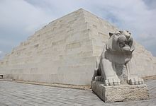
| Mausoleum of Tangun | |
 The Mausoleum of Tangun The Mausoleum of Tangun | |
| Korean name | |
|---|---|
| Chosŏn'gŭl | 단군릉 |
| Hancha | 檀君陵 |
| Revised Romanization | Dangulleung |
| McCune–Reischauer | Tan'gullŭng |
| This article needs better sources. Please help improve this article by adding more reliable sources to verify the information. Unsourced or poorly sourced material may be challenged and removed. Find sources: "Mausoleum of Tangun" – news · newspapers · books · scholar · JSTOR (September 2024) (Learn how and when to remove this message) |
The Mausoleum of Tangun is an ancient burial site in Kangdong near Pyongyang, North Korea. It is claimed by North Korea to be the tomb of Tangun, legendary founder of Gojoseon, the first Korean kingdom.
A pyramid was built on top of the grave in 1994, consisting of 1994 blocks of stone. The complex occupies about 1.8 km² (.70 mi²) on the slope of Mount Taebak (대박산). The complex is divided into three major sections: restoration work area, stone statue area, and the burial site. Dangun's grave is shaped like a step pyramid, about 22 m (72 ft) high and 50 m (164 ft) on each side.
According to the Samguk Yusa, Gojoseon was thought to have been founded in 2333 BCE. North Koreans claim that their current excavations have dramatically changed the estimates of North Korean historians back to at least 3000 BCE, making the site c.5011 years old (±267 years in 1993).
Background
North Korea's leader Kim Il Sung insisted that Dangun was not merely a legend but a real historical person. As consequence, North Korean archaeologists were compelled to locate the purported remains and grave of Dangun. In the October of 1993, through the thesis called the "Excavation reports of the mausoleum of Dangun(단군릉발굴보고)", North Korean academia announced that 86 human bone remains were found that can be traced to two individuals, one man and the other woman, and by dating the bone of the man using the method of electron spin resonance dating, it was found to be from more than 5011 years ago.
Controversy
| This section does not cite any sources. Please help improve this section by adding citations to reliable sources. Unsourced material may be challenged and removed. (July 2016) (Learn how and when to remove this message) |
A nail found in the mausoleum, dating to the Goguryeo period (37 BCE-668 CE), has been the subject of much controversy. This discovery has thus led some North Korean historians to conclude that the mausoleum was discovered and renovated during that period. Many observers and historians outside of North Korea, including South Korea, consider the data and the interpretation compromised by politics and nationalism. North Korea has permitted no independent testing to resolve the questions over authenticity and dating. South Korean historians think its more likely to be a tomb of a regional power during the Goguryeo kingdom based on the artifacts found at the site.
See also
- List of tombs and mausoleums
- List of archeological sites in Korea
- History of Korea
- Mausoleum of the Yellow Emperor
References
- "King Tangun and His Mausoleum". Uriminzokkiri. Archived from the original on 22 June 2022. Retrieved 19 January 2021.
- Tertitskiy, Fyodor (6 June 2016). "The good things in North Korea". NK News. Retrieved 20 July 2016.
- "단군릉". Encyclopedia of Korean Culture.
Further reading
- Tangun : Founder-king of Korea (Collection of Treatises) (PDF). Pyongyang: Foreign Languages Publishing House. 1994. OCLC 272459364.
External links
- King Tangun's Mausoleum at Naenara
- The Tomb of King Dan-gun, from official postcards purchased there by David A. Mason
- Images, Tomb and Relics of Founding-King Dan-gun, from a 1994 research-book in English by David A. Mason
Websites dealing with the controversy
- http://san-shin.org/dan-gun-1.html
- https://archive.today/20010404054658/http://web.edunet4u.net/~lost/
- https://web.archive.org/web/20050204054431/http://www.kimsoft.com/2002/danggun.htm
- http://pyongyang.news-site.net/rekisiminzoku/choson/dangun/index.htm Archived 2022-08-16 at the Wayback Machine
39°09′17″N 126°03′16″E / 39.154782°N 126.054382°E / 39.154782; 126.054382
Categories: