| Kangdong County 강동군 | |
|---|---|
| County | |
| Korean transcription(s) | |
| • Hanja | 江東郡 |
| • McCune-Reischauer | Kangdong-gun |
| • Revised Romanization | Gangdong-gun |
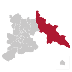
 Location of Kangdong County within Pyongyang Location of Kangdong County within Pyongyang | |
| Coordinates: 39°5′26.99″N 126°8′12.01″E / 39.0908306°N 126.1366694°E / 39.0908306; 126.1366694 | |
| Country | North Korea |
| Direct-administered city | P'yŏngyang-Chikhalsi |
| Area | |
| • Total | 536.1 km (207.0 sq mi) |
| Population | |
| • Total | 221,539 |
| • Density | 410/km (1,100/sq mi) |
Kangdong County is one of Pyongyang's two suburban counties. In 1983 it was separated from South P'yongan Province and assumed direct governance by the Pyongyang City People's Committee. It is bordered by Sŏngch'ŏn-gun (Songchon County), South P'yongan in the north and east, Sŭngho-guyŏk (Sungho District) from the south and the Taedong River from the west.
Kangdong-gun is best known as the location of the supposed Tomb of King Tangun, the Revolutionary Site at Ponghwa-ri. Kim Jong-un's Kangdong Residence is located near the banks of Taedong River. The northeastern part of the county hosts the offices and facilities of the Second Economic Committee, which is the DPRK's weapons industry. Kyo-hwa-so No. 4 is a large reeducation camp in the south eastern part of Kangdong-gun.
Administrative divisions
Kangdong County is divided into 1 ŭp (town), 6 rodongjagu (workers' districts) and 16 ri (villages):
|
|
References
- North Korea: Administrative Division
- "The Palaces of Pyongyang on Google Earth". One Free Korea. Retrieved June 5, 2012.
- "KWP Leadership Compound: Kangdong Residence". Wikimapia. Retrieved June 5, 2012.
- "The Hidden Gulag – Exposing Crimes against Humanity in North Korea's Vast Prison System (p. 109, p. 226)" (PDF). The Committee for Human Rights in North Korea. Archived from the original (PDF) on March 13, 2015. Retrieved September 21, 2012.
This North Korea location article is a stub. You can help Misplaced Pages by expanding it. |