| McMillans Road Northern and eastern suburbs, Darwin Northern Territory | |
|---|---|
 | |
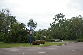
| Entrance to Peter McAulay Centre, NT Police, Fire and Emergency Services Headquarters off McMillans Road | |
| General information | |
| Type | Road |
| Length | 13.2 km (8.2 mi) |
| Opened | 1920s |
| Major junctions | |
| West end | Bagot Road, Millner |
| SW end | Stuart Highway, Knuckey Lagoon |
| Location(s) | |
| Major suburbs | Jingili, Moil, Marrara, Anula, Malak, Karama, Berrimah |
McMillans Road is a major arterial road in the northern and eastern suburbs of Darwin, Northern Territory Australia. The road provides an access route for some of the city's most important infrastructure including Darwin International Airport, Northern Territory Institute of Sport, Marrara Oval and the headquarters and training college of the Northern Territory Police. It is also the main road access to Crocodylus Park, a major tourist attraction boasting a crocodile farm and small zoo. The road is named for the McMillan brothers as it was originally the access to pastoral leases they held in the 1920s and 1930s.
McMillans Road was extended in 1999 to provide through access to the Stuart Highway, improving access between Palmerston and Royal Darwin Hospital located in Tiwi in the northern suburbs as well as the commercial district of Casuarina.
See also
References
- "Place Names Register".
- "Archived copy" (PDF). Archived from the original (PDF) on 8 April 2011. Retrieved 4 November 2012.
{{cite web}}: CS1 maint: archived copy as title (link)
| Road infrastructure in Northern Territory | ||
|---|---|---|
| National highways | ||
| Highways | ||
| Major urban roads | ||
| Outback tracks and numbered state routes | ||