| Roper Highway Northern Territory | |
|---|---|
 | |
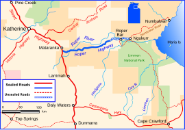
| Roper Highway (depicted in blue) | |
| General information | |
| Type | Rural road |
| Length | 206 km (128 mi) |
| Route number(s) | (Mataranka – Ngukurr) |
| Major junctions | |
| SW end | |
| NE end | Ngukurr |
| Location(s) | |
| Major settlements | Elsey, Roper Valley, Roper Bar, Ngukurr |
The Roper Highway is a road in the Northern Territory of Australia that begins from a point on the Stuart Highway 7 kilometres south of Mataranka, and runs east along the Roper River via Roper Bar to Ngukurr. Its length is 206 kilometres. From Ngukurr the road continues for approximately 153 kilometres to Numbulwar on the Gulf of Carpentaria as the Numbulwar Road. The section of the highway between Roper Bar and Ngukurr is also known as the Ngukurr Access.
See also
References
- Transport Infrastructure Planning Division, NT Govt.
- Hema, Maps (2007). Australia Road and 4WD Atlas (Map). Eight Mile Plains Queensland: Hema Maps. pp. 96–97. ISBN 978-1-86500-456-3.
- Department of Transport (April 1998). "Map of all NT Roads" (PDF). Northern Territory Government. Archived from the original (PDF) on 5 May 2013. Retrieved 13 January 2014.
| Road infrastructure in Northern Territory | ||
|---|---|---|
| National highways | ||
| Highways | ||
| Major urban roads | ||
| Outback tracks and numbered state routes | ||
This Australian road or road transport-related article is a stub. You can help Misplaced Pages by expanding it. |
This Northern Territory, Australia article is a stub. You can help Misplaced Pages by expanding it. |